Weather Alert in Connecticut
Special Weather Statement issued March 6 at 9:32PM EST by NWS Boston/Norton MA
AREAS AFFECTED: Hartford; Tolland; Windham; Western Franklin; Eastern Franklin; Northern Worcester; Central Middlesex County; Western Essex; Eastern Essex; Western Hampshire; Western Hampden; Eastern Hampshire; Eastern Hampden; Southern Worcester; Western Norfolk; Southeast Middlesex; Suffolk; Eastern Norfolk; Northern Bristol; Western Plymouth; Eastern Plymouth; Southern Bristol; Southern Plymouth; Barnstable; Dukes; Northwest Middlesex County; Northwest Providence; Southeast Providence; Western Kent; Eastern Kent; Bristol; Washington; Newport
DESCRIPTION: Areas of drizzle with pockets of freezing drizzle will continue into early Saturday morning. The bulk of the freezing drizzle will be in the high terrain where temperatures were at or below freezing and untreated roads maybe icy. However...even some of the lower elevations had temperatures around 32 degrees which may lead to some patchy black ice. Plan on allowing extra travel time and be especially careful on bridges and overpasses. This is particularly true in the high terrain where temperatures were a few degrees below freezing. Pedestrians should also be careful in parking lots and walkways which may have patches of black ice. Temperatures will warm above freezing by mid to late Saturday morning alleviating any issues.
INSTRUCTION: N/A
Want more detail? Get the Complete 7 Day and Night Detailed Forecast!
Current U.S. National Radar--Current
The Current National Weather Radar is shown below with a UTC Time (subtract 5 hours from UTC to get Eastern Time).

National Weather Forecast--Current
The Current National Weather Forecast and National Weather Map are shown below.

National Weather Forecast for Tomorrow
Tomorrow National Weather Forecast and Tomorrow National Weather Map are show below.

North America Water Vapor (Moisture)
This map shows recent moisture content over North America. Bright and colored areas show high moisture (ie, clouds); brown indicates very little moisture present; black indicates no moisture.

Weather Topic: What is Condensation?
Home - Education - Precipitation - Condensation
 Next Topic: Contrails
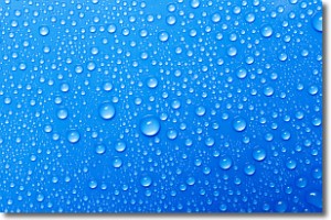
Condensation is the process which creates clouds, and therefore
it is a crucial process in the water cycle.
Condensation is the change of matter from a state of gas into a state of liquid,
and it happens because water molecules release heat into the atmosphere and
become organized into a more closely packed structure, what we might see as
water droplets.
Water is always present in the air around us as a vapor, but it's too small for
us to see. When water undergoes the process of condensation it becomes organized
into visible water droplets. You've probably seen condensation happen before on the
surface of a cold drink!
Next Topic: Contrails
Weather Topic: What are Cumulonimbus Clouds?
Home - Education - Cloud Types - Cumulonimbus Clouds
 Next Topic: Cumulus Clouds
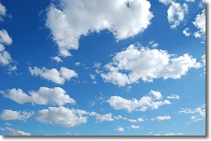
The final form taken by a growing cumulus cloud is the
cumulonimbus cloud, which is very tall and dense.
The tower of a cumulonimbus cloud can soar 23 km into the atmosphere, although
most commonly they stop growing at an altitude of 6 km.
Even small cumulonimbus clouds appear very large in comparison to other cloud types.
They can signal the approach of stormy weather, such as thunderstorms or blizzards.
Next Topic: Cumulus Clouds
Current conditions powered by WeatherAPI.com


