Weather Alert in North Carolina
Winter Storm Warning issued February 21 at 9:49PM EST until February 24 at 12:00AM EST by NWS Greenville-Spartanburg SC
AREAS AFFECTED: Avery
DESCRIPTION: * WHAT...Heavy snow expected. Total snow accumulations mostly between 2 and 6 inches, with amounts up to 10 inches possible along the Tennessee border and in the high elevations. * WHERE...Avery County. * WHEN...From midnight tonight until midnight EST Monday Night. * IMPACTS...The heavy snow will make many roads impassable and may produce a few power outages due to the weight of the snow on tree limbs and power lines. The hazardous conditions could impact the Monday morning and evening commutes. * ADDITIONAL DETAILS...Winds gusting as high as 50 mph could result in areas of blowing snow and very low visibility Sunday night and Monday.
INSTRUCTION: Monitor the latest forecasts for updates on this situation. Slow down and use caution while traveling. If you must travel, keep an extra flashlight, food, and water in your vehicle in case of an emergency. The latest road conditions for the state you are calling from can be obtained by calling 5 1 1.
Want more detail? Get the Complete 7 Day and Night Detailed Forecast!
Current U.S. National Radar--Current
The Current National Weather Radar is shown below with a UTC Time (subtract 5 hours from UTC to get Eastern Time).

National Weather Forecast--Current
The Current National Weather Forecast and National Weather Map are shown below.

National Weather Forecast for Tomorrow
Tomorrow National Weather Forecast and Tomorrow National Weather Map are show below.

North America Water Vapor (Moisture)
This map shows recent moisture content over North America. Bright and colored areas show high moisture (ie, clouds); brown indicates very little moisture present; black indicates no moisture.

Weather Topic: What is Fog?
Home - Education - Cloud Types - Fog
 Next Topic: Fractus Clouds
Fog is technically a type of stratus cloud, which lies along the
ground and obscures visibility.
It is usually created when humidity in the air condenses into tiny water droplets.
Because of this, some places are more prone to foggy weather, such as regions
close to a body of water.
Fog is similar to mist; both are the appearance of water droplets suspended in
the air, but fog is the term applied to the condition when visibility is less than 1 km.
Next Topic: Fractus Clouds
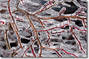
Weather Topic: What is Freezing Rain?
Home - Education - Precipitation - Freezing Rain
 Next Topic: Graupel
Freezing rain is a condition where precipitation which has fallen in the form of
water droplets reaches temperatures which are below freezing and freezes upon
coming into contact
with surface objects. The result of this precipitation is a glaze of ice which
can be damaging to plants and man-made structures. A severe onset of freezing
rain which results in a very thick glaze of ice is known as an ice storm.
Next Topic: Graupel
Current conditions powered by WeatherAPI.com


