Weather Alert in Florida
Fire Weather Watch issued February 22 at 12:53AM EST until February 23 at 7:00PM EST by NWS Jacksonville FL
AREAS AFFECTED: Suwannee; Baker; Inland Nassau; Union; Bradford; Gilchrist; Inland Flagler; Eastern Hamilton; Coastal Nassau; Coastal Duval; Eastern Clay; Eastern Alachua; Eastern Putnam; Coastal Flagler; Eastern Marion; Western Hamilton; Trout River; Western Clay; Northeast Coastal St. Johns; Western Alachua; Western Putnam; Central Marion; Northern Columbia; South Central Duval; Southeast Coastal St. Johns; Western Marion; Southeastern Columbia; Western Duval; Northern Inland St. Johns; Southwestern Columbia; Southern Inland St. Johns; Western St. Johns; Echols; Clinch; Northeastern Charlton; Southern Ware; Western Charlton
DESCRIPTION: ...RED FLAG WARNING THIS AFTERNOON AND EVENING FOR LOCATIONS FROM WAYCROSS SOUTHWARD... ...FIRE WEATHER WATCHES REMAIN POSTED AREA-WIDE FROM EARLY MONDAY AFTERNOON THROUGH EARLY MONDAY EVENING... ...FIRE WEATHER WATCH REMAINS IN EFFECT FROM MONDAY AFTERNOON THROUGH MONDAY EVENING FOR LOW HUMIDITY AND STRONG NORTHWESTERLY WINDS FOR ALL OF SOUTHEAST GEORGIA, NORTHEAST AND NORTH CENTRAL FLORIDA... * AFFECTED AREA...In Florida, Suwannee, Baker, Inland Nassau, Union, Bradford, Gilchrist, Inland Flagler, Eastern Hamilton, Coastal Nassau, Coastal Duval, Eastern Clay, Eastern Alachua, Eastern Putnam, Coastal Flagler, Eastern Marion, Western Hamilton, Trout River, Western Clay, Northeast Coastal St. Johns, Western Alachua, Western Putnam, Central Marion, Northern Columbia, South Central Duval, Southeast Coastal St. Johns, Western Marion, Southeastern Columbia, Western Duval, Northern Inland St. Johns, Southwestern Columbia, Southern Inland St. Johns and Western St. Johns. In Georgia, Echols, Clinch, Northeastern Charlton, Southern Ware and Western Charlton. * TIMING...1 PM to 9 PM Sunday. * WINDS...Northwest 15 to 25 mph with gusts up to 35 mph. * RELATIVE HUMIDITY...As low as 20 percent. * TEMPERATURES...Up to 72. * IMPACTS...Ongoing wildfires will become difficult to contain and newly ignited fires may exhibit erratic fire behavior. Rapid rates of wildfire spread is expected.
INSTRUCTION: A Red Flag Warning means that critical fire weather conditions are either occurring now, or will shortly. A combination of strong winds, low relative humidity, and warm temperatures can contribute to extreme fire behavior. A Fire Weather Watch means that critical fire weather conditions are forecast to occur. Listen for later forecasts and possible Red Flag Warnings.
Want more detail? Get the Complete 7 Day and Night Detailed Forecast!
Current U.S. National Radar--Current
The Current National Weather Radar is shown below with a UTC Time (subtract 5 hours from UTC to get Eastern Time).

National Weather Forecast--Current
The Current National Weather Forecast and National Weather Map are shown below.

National Weather Forecast for Tomorrow
Tomorrow National Weather Forecast and Tomorrow National Weather Map are show below.

North America Water Vapor (Moisture)
This map shows recent moisture content over North America. Bright and colored areas show high moisture (ie, clouds); brown indicates very little moisture present; black indicates no moisture.

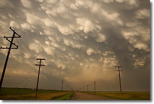
Weather Topic: What are Mammatus Clouds?
Home - Education - Cloud Types - Mammatus Clouds
 Next Topic: Nimbostratus Clouds
A mammatus cloud is a cloud with a unique feature which resembles
a web of pouches hanging along the base of the cloud.
In the United States, mammatus clouds tend to form in the warmer months, commonly
in the Midwest and eastern regions.
While they usually form at the bottom of a cumulonimbis cloud, they can also form
under altostratus, altocumulus, stratocumulus, and cirrus clouds. Mammatus clouds
warn that severe weather is close.
Next Topic: Nimbostratus Clouds
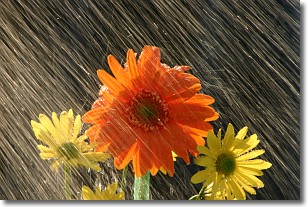
Weather Topic: What is Precipitation?
Home - Education - Precipitation - Precipitation
 Next Topic: Rain
Precipitation can refer to many different forms of water that
may fall from clouds. Precipitation occurs after a cloud has become saturated to
the point where its water particles are more dense than the air below the cloud.
In most cases, precipitation will reach the ground, but it is not uncommon for
precipitation to evaporate before it reaches the earth's surface.
When precipitation evaporates before it contacts the ground it is called Virga.
Graupel, hail, sleet, rain, drizzle, and snow are forms of precipitation, but fog
and mist are not considered precipitation because the water vapor which
constitutes them isn't dense enough to fall to the ground.
Next Topic: Rain
Current conditions powered by WeatherAPI.com


