Weather Alert in Florida
Red Flag Warning issued February 22 at 12:53AM EST until February 22 at 9:00PM EST by NWS Jacksonville FL
AREAS AFFECTED: Suwannee; Baker; Inland Nassau; Union; Bradford; Gilchrist; Inland Flagler; Eastern Hamilton; Coastal Nassau; Coastal Duval; Eastern Clay; Eastern Alachua; Eastern Putnam; Coastal Flagler; Eastern Marion; Western Hamilton; Trout River; Western Clay; Northeast Coastal St. Johns; Western Alachua; Western Putnam; Central Marion; Northern Columbia; South Central Duval; Southeast Coastal St. Johns; Western Marion; Southeastern Columbia; Western Duval; Northern Inland St. Johns; Southwestern Columbia; Southern Inland St. Johns; Western St. Johns; Echols; Clinch; Northeastern Charlton; Southern Ware; Western Charlton
DESCRIPTION: ...RED FLAG WARNING THIS AFTERNOON AND EVENING FOR LOCATIONS FROM WAYCROSS SOUTHWARD... ...FIRE WEATHER WATCHES REMAIN POSTED AREA-WIDE FROM EARLY MONDAY AFTERNOON THROUGH EARLY MONDAY EVENING... ...FIRE WEATHER WATCH REMAINS IN EFFECT FROM MONDAY AFTERNOON THROUGH MONDAY EVENING FOR LOW HUMIDITY AND STRONG NORTHWESTERLY WINDS FOR ALL OF SOUTHEAST GEORGIA, NORTHEAST AND NORTH CENTRAL FLORIDA... * AFFECTED AREA...In Florida, Suwannee, Baker, Inland Nassau, Union, Bradford, Gilchrist, Inland Flagler, Eastern Hamilton, Coastal Nassau, Coastal Duval, Eastern Clay, Eastern Alachua, Eastern Putnam, Coastal Flagler, Eastern Marion, Western Hamilton, Trout River, Western Clay, Northeast Coastal St. Johns, Western Alachua, Western Putnam, Central Marion, Northern Columbia, South Central Duval, Southeast Coastal St. Johns, Western Marion, Southeastern Columbia, Western Duval, Northern Inland St. Johns, Southwestern Columbia, Southern Inland St. Johns and Western St. Johns. In Georgia, Echols, Clinch, Northeastern Charlton, Southern Ware and Western Charlton. * TIMING...1 PM to 9 PM Sunday. * WINDS...Northwest 15 to 25 mph with gusts up to 35 mph. * RELATIVE HUMIDITY...As low as 20 percent. * TEMPERATURES...Up to 72. * IMPACTS...Ongoing wildfires will become difficult to contain and newly ignited fires may exhibit erratic fire behavior. Rapid rates of wildfire spread is expected.
INSTRUCTION: A Red Flag Warning means that critical fire weather conditions are either occurring now, or will shortly. A combination of strong winds, low relative humidity, and warm temperatures can contribute to extreme fire behavior. A Fire Weather Watch means that critical fire weather conditions are forecast to occur. Listen for later forecasts and possible Red Flag Warnings.
Want more detail? Get the Complete 7 Day and Night Detailed Forecast!
Current U.S. National Radar--Current
The Current National Weather Radar is shown below with a UTC Time (subtract 5 hours from UTC to get Eastern Time).

National Weather Forecast--Current
The Current National Weather Forecast and National Weather Map are shown below.

National Weather Forecast for Tomorrow
Tomorrow National Weather Forecast and Tomorrow National Weather Map are show below.

North America Water Vapor (Moisture)
This map shows recent moisture content over North America. Bright and colored areas show high moisture (ie, clouds); brown indicates very little moisture present; black indicates no moisture.

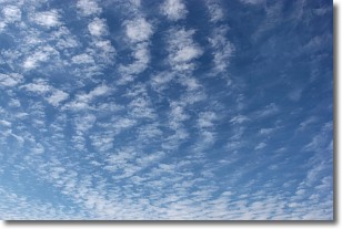
Weather Topic: What are Cirrocumulus Clouds?
Home - Education - Cloud Types - Cirrocumulus Clouds
 Next Topic: Cirrostratus Clouds
Cirrocumulus clouds form at high altitudes (usually around 5 km)
and have distinguishing characteristics displayed in a fine layer of
small cloud patches. These small cloud patches are sometimes referred to as
"cloudlets" in relation to the whole cloud formation.
Cirrocumulus clouds are formed from ice crystals and water droplets. Often, the
water droplets in the cloud freeze into ice crystals and the cloud becomes a
cirrostratus cloud. Because of this common occurrence, cirrocumulus cloud
formations generally pass rapidly.
Next Topic: Cirrostratus Clouds
Weather Topic: What are Cirrus Clouds?
Home - Education - Cloud Types - Cirrus Clouds
 Next Topic: Condensation
Cirrus clouds are high-level clouds that occur above 20,000 feet
and are composed mainly of ice crystals.
They are thin and wispy in appearance.
What do they indicate?
They are often the first sign of an approaching storm.
Next Topic: Condensation
Current conditions powered by WeatherAPI.com


