Weather Alert in Texas
Red Flag Warning issued February 21 at 11:46PM CST until February 22 at 6:00PM CST by NWS Corpus Christi TX
AREAS AFFECTED: McMullen; Live Oak; Bee; Goliad; Victoria; Duval; Jim Wells; Inland Kleberg; Inland Nueces; Inland San Patricio; Coastal Aransas; Inland Refugio; Inland Calhoun; Coastal Kleberg; Coastal Nueces; Coastal San Patricio; Coastal Refugio; Coastal Calhoun
DESCRIPTION: ...CRITICAL FIRE WEATHER CONDITIONS SUNDAY... .Strong winds will continue across the Coastal Plains and Brush country through the day Sunday. This, along with very low RH values will result in critical fire weather conditions across the warned area. . The National Weather Service in Corpus Christi has issued a Red Flag Warning for the Coastal Plains and Brush Country, which is in effect from 9 AM to 6 PM CST Sunday. * AFFECTED AREA...McMullen, Live Oak, Bee, Goliad, Victoria, Duval, Jim Wells, Inland Kleberg, Inland Nueces, Inland San Patricio, Coastal Aransas, Inland Refugio, Inland Calhoun, Coastal Kleberg, Coastal Nueces, Coastal San Patricio, Coastal Refugio and Coastal Calhoun. * TIMING... 9 AM to 6 PM * WINDS...Northeast 15 to 20 mph with gusts up to 30 mph. * RELATIVE HUMIDITY...As low as 14 percent. * TEMPERATURES...Up to 70. * IMPACTS...Any fires that develop will likely spread rapidly. Outdoor burning is not recommended
INSTRUCTION: A Red Flag Warning means that critical fire weather conditions are either occurring now...or will shortly. A combination of strong winds...low relative humidity...and warm temperatures can contribute to extreme fire behavior. Residents are urged to exercise care with respect to all outdoor activities that could inadvertently cause wildfires. Report wildfires quickly to the nearest fire department or law enforcement office.
Want more detail? Get the Complete 7 Day and Night Detailed Forecast!
Current U.S. National Radar--Current
The Current National Weather Radar is shown below with a UTC Time (subtract 5 hours from UTC to get Eastern Time).

National Weather Forecast--Current
The Current National Weather Forecast and National Weather Map are shown below.

National Weather Forecast for Tomorrow
Tomorrow National Weather Forecast and Tomorrow National Weather Map are show below.

North America Water Vapor (Moisture)
This map shows recent moisture content over North America. Bright and colored areas show high moisture (ie, clouds); brown indicates very little moisture present; black indicates no moisture.

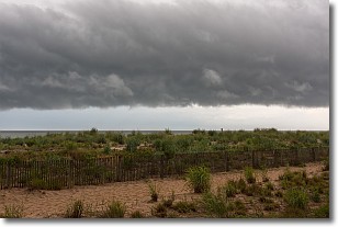
Weather Topic: What are Shelf Clouds?
Home - Education - Cloud Types - Shelf Clouds
 Next Topic: Sleet
A shelf cloud is similar to a wall cloud, but forms at the front
of a storm cloud, instead of at the rear, where wall clouds form.
A shelf cloud is caused by a series of events set into motion by the advancing
storm; first, cool air settles along the ground where precipitation has just fallen.
As the cool air is brought in, the warmer air is displaced, and rises above it,
because it is less dense. When the warmer air reaches the bottom of the storm cloud,
it begins to cool again, and the resulting condensation is a visible shelf cloud.
Next Topic: Sleet
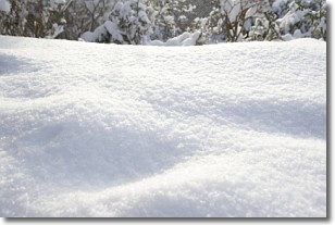
Weather Topic: What is Snow?
Home - Education - Precipitation - Snow
 Next Topic: Stratocumulus Clouds
Snow is precipitation taking the form of ice crystals. Each ice crystal, or snowflake,
has unique characteristics, but all of them grow in a hexagonal structure.
Snowfall can last for sustained periods of time and result in significant buildup
of snow on the ground.
On the earth's surface, snow starts out light and powdery, but as it begins to melt
it tends to become more granular, producing small bits of ice which have the consistency of
sand. After several cycles of melting and freezing, snow can become very dense
and ice-like, commonly known as snow pack.
Next Topic: Stratocumulus Clouds
Current conditions powered by WeatherAPI.com


