Weather Alert in Idaho
Avalanche Warning issued February 24 at 7:58PM MST by NWS Pocatello ID
AREAS AFFECTED: Caribou Range; Big Hole Mountains
DESCRIPTION: AVWPIH * WHAT...Avalanche warning. The avalanche danger is high due to heavy rates of snowfall and intense wind. * WHERE...The mountains of southeast Idaho including the Snake River Range, Caribou Range, and Big Holes. The mountains of western Wyoming including the Tetons, Snake River, Salt River, and Wyoming ranges. * WHEN...In effect from Tuesday at 10 PM MST to Wednesday at 10 PM MST. * IMPACTS...Heavy snowfall combined with strong wind will create widespread areas of unstable snow and overload buried weak layers. Natural and human-triggered avalanches will be very likely across all aspects above 7,000 feet for backcountry recreationalists.
INSTRUCTION: Very dangerous avalanche conditions. Travel in avalanche terrain is not recommended. Gentle terrain below large avalanche paths could be impacted. Consult www.btavy.org or www.avalanche.org for more detailed information. Similar avalanche danger may exist at locations outside the coverage area of this or any avalanche center.
Want more detail? Get the Complete 7 Day and Night Detailed Forecast!
Current U.S. National Radar--Current
The Current National Weather Radar is shown below with a UTC Time (subtract 5 hours from UTC to get Eastern Time).

National Weather Forecast--Current
The Current National Weather Forecast and National Weather Map are shown below.

National Weather Forecast for Tomorrow
Tomorrow National Weather Forecast and Tomorrow National Weather Map are show below.

North America Water Vapor (Moisture)
This map shows recent moisture content over North America. Bright and colored areas show high moisture (ie, clouds); brown indicates very little moisture present; black indicates no moisture.

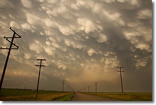
Weather Topic: What are Mammatus Clouds?
Home - Education - Cloud Types - Mammatus Clouds
 Next Topic: Nimbostratus Clouds
A mammatus cloud is a cloud with a unique feature which resembles
a web of pouches hanging along the base of the cloud.
In the United States, mammatus clouds tend to form in the warmer months, commonly
in the Midwest and eastern regions.
While they usually form at the bottom of a cumulonimbis cloud, they can also form
under altostratus, altocumulus, stratocumulus, and cirrus clouds. Mammatus clouds
warn that severe weather is close.
Next Topic: Nimbostratus Clouds
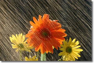
Weather Topic: What is Precipitation?
Home - Education - Precipitation - Precipitation
 Next Topic: Rain
Precipitation can refer to many different forms of water that
may fall from clouds. Precipitation occurs after a cloud has become saturated to
the point where its water particles are more dense than the air below the cloud.
In most cases, precipitation will reach the ground, but it is not uncommon for
precipitation to evaporate before it reaches the earth's surface.
When precipitation evaporates before it contacts the ground it is called Virga.
Graupel, hail, sleet, rain, drizzle, and snow are forms of precipitation, but fog
and mist are not considered precipitation because the water vapor which
constitutes them isn't dense enough to fall to the ground.
Next Topic: Rain
Current conditions powered by WeatherAPI.com


