Weather Alert in Kentucky
Winter Weather Advisory issued February 23 at 2:55AM EST until February 23 at 7:00PM EST by NWS Jackson KY
AREAS AFFECTED: Harlan; Floyd; Knott; Perry; Letcher; Martin; Pike
DESCRIPTION: * WHAT...Rounds of snow showers. Additional snow accumulations between 4 AM through 7 PM EST of a half an inch to 2 inches. Locally higher amounts are possible in any areas of more persistent snow showers. Accumulations up to 4 inches are possible above 3000 feet elevation. * WHERE...Portions of northeast and southeast Kentucky. * WHEN...Until 7 PM EST this evening. * IMPACTS...Plan on times of slick, slushy, or snow covered roads and significant differences in road conditions over rather short distances. During or following a snow shower, any untreated roads and surfaces, as well as bridges and overpasses, may be icy in some locations. The hazardous conditions could impact the morning and evening commutes. * ADDITIONAL DETAILS...Wind gusts as high as 30 mph are possible in the heavier snow showers, combined with the falling snow may cause sudden visibility reductions.
INSTRUCTION: If traveling today, slow down and exercise caution. Allow plenty of extra time to reach your destination. The latest road conditions for Kentucky can be found by visiting https://goky.ky.gov.
Want more detail? Get the Complete 7 Day and Night Detailed Forecast!
Current U.S. National Radar--Current
The Current National Weather Radar is shown below with a UTC Time (subtract 5 hours from UTC to get Eastern Time).

National Weather Forecast--Current
The Current National Weather Forecast and National Weather Map are shown below.

National Weather Forecast for Tomorrow
Tomorrow National Weather Forecast and Tomorrow National Weather Map are show below.

North America Water Vapor (Moisture)
This map shows recent moisture content over North America. Bright and colored areas show high moisture (ie, clouds); brown indicates very little moisture present; black indicates no moisture.

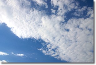
Weather Topic: What are Stratus Clouds?
Home - Education - Cloud Types - Stratus Clouds
 Next Topic: Wall Clouds
Stratus clouds are similar to altostratus clouds, but form at a
lower altitude and are identified by their fog-like appearance, lacking the
distinguishing features of most clouds.
Stratus clouds are wider than most clouds, and their base has a smooth, uniform
look which is lighter in color than a nimbostratus cloud.
The presence of a stratus cloud indicates the possibility of minor precipitation,
such as drizzle, but heavier precipitation does not typically arrive in the form
of a stratus cloud.
Next Topic: Wall Clouds
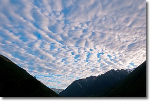
Weather Topic: What are Altocumulus Clouds?
Home - Education - Cloud Types - Altocumulus Clouds
 Next Topic: Altostratus Clouds
Similar to cirrocumulus clouds, altocumulus clouds are
characterized by cloud patches. They are distinguished by larger cloudlets
than cirrocumulus clouds but are still smaller than stratocumulus clouds.
Altocumulus clouds most commonly form in middle altitudes (between 2 and 5 km)
and may resemble, at times, the shape of a flying saucer.
These uncommon formations, called altocumulus lenticularis, are created by uplift
in the atmosphere and are most often seen in close proximity to mountains.
Next Topic: Altostratus Clouds
Current conditions powered by WeatherAPI.com


