Weather Alert in Indiana
Flood Warning issued March 4 at 12:07PM EST by NWS Indianapolis IN
AREAS AFFECTED: Jackson, IN; Lawrence, IN; Washington, IN
DESCRIPTION: ...The Flood Warning is extended for the following rivers in Indiana... Big Blue River at Shelbyville. East Fork White River at Seymour. Flatrock River near Columbus. East Fork White River at Columbus. .Rainfall amounts between two and four inches over parts of central and southern Indiana have led to rises and some flooding on area rivers. Additional rainfall of one to three inches this evening into Thursday morning, with locally higher amounts possible, will bring widespread minor river flooding with pockets of moderate flooding to much of the East Fork White and lower White River basins. * WHAT...Minor flooding is occurring and moderate flooding is forecast. * WHERE...East Fork White River at Seymour. * WHEN...From this morning until further notice. * IMPACTS...At 18.2 feet, Flood waters begin to cross CR 760E near Seymour Water Plant just south of CR 725N. Extensive flooding and CR 760E flooded south of Seymour Water Plant. Many local roads are flooded. * ADDITIONAL DETAILS... - At 10:45 AM EST Wednesday the stage was 12.3 feet. - Recent Activity...The maximum river stage in the 24 hours ending at 10:45 AM EST Wednesday was 12.3 feet. - Forecast...The river is expected to rise to a crest of 18.1 feet early Friday afternoon. - Flood stage is 12.0 feet. - http://www.weather.gov/safety/flood
INSTRUCTION: Motorists should not attempt to drive around barricades or drive cars through flooded areas. Additional information is available at www.weather.gov/ind. The next statement should be issued this evening by around 1115 PM EST.
Want more detail? Get the Complete 7 Day and Night Detailed Forecast!
Current U.S. National Radar--Current
The Current National Weather Radar is shown below with a UTC Time (subtract 5 hours from UTC to get Eastern Time).

National Weather Forecast--Current
The Current National Weather Forecast and National Weather Map are shown below.

National Weather Forecast for Tomorrow
Tomorrow National Weather Forecast and Tomorrow National Weather Map are show below.

North America Water Vapor (Moisture)
This map shows recent moisture content over North America. Bright and colored areas show high moisture (ie, clouds); brown indicates very little moisture present; black indicates no moisture.

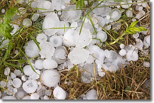
Weather Topic: What is Hail?
Home - Education - Precipitation - Hail
 Next Topic: Hole Punch Clouds
Hail is a form of precipitation which is recognized by large solid balls or
clumps of ice. Hail is created by thunderstorm clouds with strong updrafts of wind.
As the hailstones remain in the updraft, ice is deposited onto them until their
weight becomes heavy enough for them to fall to the earth's surface.
Hail storms can cause significant damage to crops, aircrafts, and man-made structures,
despite the fact that the duration is usually less than ten minutes.
Next Topic: Hole Punch Clouds
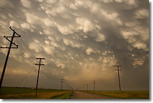
Weather Topic: What are Mammatus Clouds?
Home - Education - Cloud Types - Mammatus Clouds
 Next Topic: Nimbostratus Clouds
A mammatus cloud is a cloud with a unique feature which resembles
a web of pouches hanging along the base of the cloud.
In the United States, mammatus clouds tend to form in the warmer months, commonly
in the Midwest and eastern regions.
While they usually form at the bottom of a cumulonimbis cloud, they can also form
under altostratus, altocumulus, stratocumulus, and cirrus clouds. Mammatus clouds
warn that severe weather is close.
Next Topic: Nimbostratus Clouds
Current conditions powered by WeatherAPI.com


