Weather Alert in Montana
Avalanche Warning issued February 25 at 8:24AM MST by NWS Missoula MT
AREAS AFFECTED: Potomac/Seeley Lake Region
DESCRIPTION: AVWMSO The following message is transmitted at the request of West Central Montana Avalanche Center Missoula MT. ...AVALANCHE WARNING ISSUED BY THE WEST CENTRAL MONTANA AVALANCHE CENTER... 07:30 MST Wed Feb 25 2026 The West Central Montana Avalanche Center in Missoula has issued a BACKCOUNTRY AVALANCHE WARNING for the following areas: NWS Missoula MT - MTZ043 (MTZ043) * WHAT...Several feet of new snow, coupled with strong ridgetop winds, have created dangerous avalanche conditions. This new snow will likely overload buried weak layers and lead to large natural avalanches. Travel in and below avalanche terrain is not recommended. * WHERE...The Seeley Lake mountains above 5500'. * WHEN...In effect from Wed 07:30 MST to Thu 04:00 MST. * IMPACTS...Natural and human-triggered avalanches are likely. Avalanches will release on weak layers buried two to four feet deep. It will be possible to remotely trigger avalanches from below, above, or to the side of steeper slopes. Avalanches may connect across terrain features, creating large and destructive avalanches. * PRECAUTIONARY / PREPAREDNESS ACTIONS...Dangerous avalanche conditions exist. Travel in avalanche terrain is not recommended. Avoid travel underneath steep slopes. Even small slopes like roadcuts and gullies have potential to deposit enough debris to bury or injure a person. Consult https://missoulaavalanche.org/ or www.avalanche.org for more detailed information. Similar avalanche danger may exist at locations outside the coverage area of this or any avalanche center.
INSTRUCTION: N/A
Want more detail? Get the Complete 7 Day and Night Detailed Forecast!
Current U.S. National Radar--Current
The Current National Weather Radar is shown below with a UTC Time (subtract 5 hours from UTC to get Eastern Time).

National Weather Forecast--Current
The Current National Weather Forecast and National Weather Map are shown below.

National Weather Forecast for Tomorrow
Tomorrow National Weather Forecast and Tomorrow National Weather Map are show below.

North America Water Vapor (Moisture)
This map shows recent moisture content over North America. Bright and colored areas show high moisture (ie, clouds); brown indicates very little moisture present; black indicates no moisture.

Weather Topic: What are Cirrus Clouds?
Home - Education - Cloud Types - Cirrus Clouds
 Next Topic: Condensation
Cirrus clouds are high-level clouds that occur above 20,000 feet
and are composed mainly of ice crystals.
They are thin and wispy in appearance.
What do they indicate?
They are often the first sign of an approaching storm.
Next Topic: Condensation
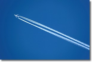
Weather Topic: What are Contrails?
Home - Education - Cloud Types - Contrails
 Next Topic: Cumulonimbus Clouds
A contrail is an artificial cloud, created by the passing of an
aircraft.
Contrails form because water vapor in the exhaust of aircraft engines is suspended
in the air under certain temperatures and humidity conditions. These contrails
are called exhaust contrails.
Another type of contrail can form due to a temporary reduction in air pressure
moving over the plane's surface, causing condensation.
These are called aerodynamic contrails.
When you can see your breath on a cold day, it is also because of condensation.
The reason contrails last longer than the condensation from your breath is
because the water in contrails freezes into ice particles.
Next Topic: Cumulonimbus Clouds
Current conditions powered by WeatherAPI.com


