Weather Alert in Indiana
Winter Weather Advisory issued February 21 at 9:12PM CST until February 23 at 12:00PM CST by NWS Chicago IL
AREAS AFFECTED: Porter
DESCRIPTION: * WHAT...Lake effect snow expected. Total snow accumulations between 2 and 5 inches, with locally higher amounts possible mainly east of State Road 49 and north of US Route 30. Some blowing and drifting snow is possible Sunday night into Monday. * WHERE...Porter County. * WHEN...Until noon CST Monday. * IMPACTS...Roads, and especially bridges and overpasses, will likely become slick and hazardous. The hazardous conditions are expected to impact the Monday morning commute. * ADDITIONAL DETAILS...A brief lull in snowfall may occur midday Sunday before another round of lake effect snow develops Sunday afternoon and evening through Monday morning.
INSTRUCTION: Slow down and use caution while traveling. The latest road conditions for Indiana can be obtained at https://511in.org.
Want more detail? Get the Complete 7 Day and Night Detailed Forecast!
Current U.S. National Radar--Current
The Current National Weather Radar is shown below with a UTC Time (subtract 5 hours from UTC to get Eastern Time).

National Weather Forecast--Current
The Current National Weather Forecast and National Weather Map are shown below.

National Weather Forecast for Tomorrow
Tomorrow National Weather Forecast and Tomorrow National Weather Map are show below.

North America Water Vapor (Moisture)
This map shows recent moisture content over North America. Bright and colored areas show high moisture (ie, clouds); brown indicates very little moisture present; black indicates no moisture.

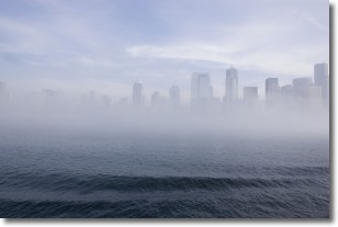
Weather Topic: What is Fog?
Home - Education - Cloud Types - Fog
 Next Topic: Fractus Clouds
Fog is technically a type of stratus cloud, which lies along the
ground and obscures visibility.
It is usually created when humidity in the air condenses into tiny water droplets.
Because of this, some places are more prone to foggy weather, such as regions
close to a body of water.
Fog is similar to mist; both are the appearance of water droplets suspended in
the air, but fog is the term applied to the condition when visibility is less than 1 km.
Next Topic: Fractus Clouds
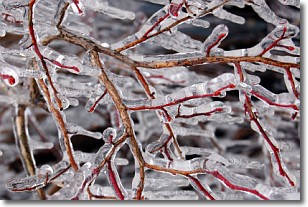
Weather Topic: What is Freezing Rain?
Home - Education - Precipitation - Freezing Rain
 Next Topic: Graupel
Freezing rain is a condition where precipitation which has fallen in the form of
water droplets reaches temperatures which are below freezing and freezes upon
coming into contact
with surface objects. The result of this precipitation is a glaze of ice which
can be damaging to plants and man-made structures. A severe onset of freezing
rain which results in a very thick glaze of ice is known as an ice storm.
Next Topic: Graupel
Current conditions powered by WeatherAPI.com


