Weather Alert in Florida
Red Flag Warning issued February 21 at 1:36PM EST until February 22 at 7:00PM EST by NWS Tallahassee FL
AREAS AFFECTED: Inland Franklin; Leon; Inland Jefferson; Madison; Inland Wakulla; Inland Taylor; Lafayette; Inland Dixie; Coastal Franklin; Coastal Jefferson; Coastal Wakulla; Coastal Taylor; Coastal Dixie; Southern Liberty
DESCRIPTION: ...RED FLAG WARNING IN EFFECT FOR THE FL BIG BEND ON SUNDAY DUE TO CRITICALLY LOW HUMIDITY AND GUSTY WINDS... .A very dry airmass and gusty winds tomorrow afternoon in the wake of tonight's cold frontal passage. Critically low relative humidity coupled with strong winds and dry fuels from the ongoing drought is expected to result in red flag conditions tomorrow afternoon. The National Weather Service in Tallahassee has issued a Red Flag Warning, which is in effect from 1 PM to 7 PM EST Sunday. * AFFECTED AREA...Fire weather zones 015, 017, 018, 019, 027, 028, 029, 034, 115, 118, 127, 128, 134, and 426. * WIND...Northwest winds 16 to 22 mph with gusts of 25 to 30 mph. * HUMIDITY...As low as 25 percent. * IMPACTS...any fires that develop will likely spread rapidly. Outdoor burning is not recommended.
INSTRUCTION: A Red Flag Warning means that critical fire weather conditions are either occurring now, or will shortly. A combination of strong winds, low relative humidity, and warm temperatures can contribute to extreme fire behavior.
Want more detail? Get the Complete 7 Day and Night Detailed Forecast!
Current U.S. National Radar--Current
The Current National Weather Radar is shown below with a UTC Time (subtract 5 hours from UTC to get Eastern Time).

National Weather Forecast--Current
The Current National Weather Forecast and National Weather Map are shown below.

National Weather Forecast for Tomorrow
Tomorrow National Weather Forecast and Tomorrow National Weather Map are show below.

North America Water Vapor (Moisture)
This map shows recent moisture content over North America. Bright and colored areas show high moisture (ie, clouds); brown indicates very little moisture present; black indicates no moisture.

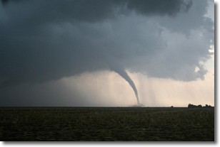
Weather Topic: What are Wall Clouds?
Home - Education - Cloud Types - Wall Clouds
 Next Topic: Altocumulus Clouds
A wall cloud forms underneath the base of a cumulonimbus cloud,
and can be a hotbed for deadly tornadoes.
Wall clouds are formed by air flowing into the cumulonimbus clouds, which can
result in the wall cloud descending from the base of the cumulonimbus cloud, or
rising fractus clouds which join to the base of the storm cloud as the wall cloud
takes shape.
Wall clouds can be very large, and in the Northern Hemisphere they generally
form at the southern edge of cumulonimbus clouds.
Next Topic: Altocumulus Clouds
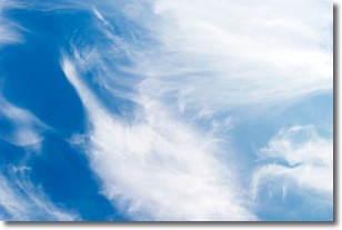
Weather Topic: What are Altostratus Clouds?
Home - Education - Cloud Types - Altostratus Clouds
 Next Topic: Cirrocumulus Clouds
Altostratus clouds form at mid to high-level altitudes
(between 2 and 7 km) and are created by a warm, stable air mass which causes
water vapor
to condense as it rise through the atmosphere. Usually altostratus clouds are
featureless sheets characterized by a uniform color.
In some cases, wind punching through the cloud formation may give it a waved
appearance, called altostratus undulatus. Altostratus clouds
are commonly seen with other cloud formations accompanying them.
Next Topic: Cirrocumulus Clouds
Current conditions powered by WeatherAPI.com


