Weather Alert in Florida
Cold Weather Advisory issued February 22 at 1:07AM EST until February 23 at 10:00AM EST by NWS Tampa Bay Ruskin FL
AREAS AFFECTED: Polk; Hardee; Highlands; DeSoto; Inland Pasco; Inland Hillsborough; Inland Manatee; Inland Charlotte
DESCRIPTION: * WHAT...For the Cold Weather Advisory, very cold wind chills as low as 29 expected. For the Freeze Watch, sub-freezing temperatures as low as 29 possible. * WHERE...Inland Charlotte, DeSoto, Hardee, Highlands, Inland Hillsborough, Inland Manatee, Inland Pasco, and Polk Counties. * WHEN...For the Cold Weather Advisory, from 3 AM to 10 AM EST Monday. For the Freeze Watch, from late Monday night through Tuesday morning. * IMPACTS...Very cold temperatures can lead to hypothermia with prolonged exposure. Frost and freeze conditions could kill crops, other sensitive vegetation and possibly damage unprotected outdoor plumbing.
INSTRUCTION: Use caution while traveling outside. Wear appropriate clothing, a hat, and gloves. Take steps now to protect tender plants from the cold.
Want more detail? Get the Complete 7 Day and Night Detailed Forecast!
Current U.S. National Radar--Current
The Current National Weather Radar is shown below with a UTC Time (subtract 5 hours from UTC to get Eastern Time).

National Weather Forecast--Current
The Current National Weather Forecast and National Weather Map are shown below.

National Weather Forecast for Tomorrow
Tomorrow National Weather Forecast and Tomorrow National Weather Map are show below.

North America Water Vapor (Moisture)
This map shows recent moisture content over North America. Bright and colored areas show high moisture (ie, clouds); brown indicates very little moisture present; black indicates no moisture.

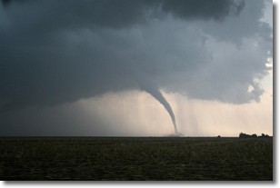
Weather Topic: What are Wall Clouds?
Home - Education - Cloud Types - Wall Clouds
 Next Topic: Altocumulus Clouds
A wall cloud forms underneath the base of a cumulonimbus cloud,
and can be a hotbed for deadly tornadoes.
Wall clouds are formed by air flowing into the cumulonimbus clouds, which can
result in the wall cloud descending from the base of the cumulonimbus cloud, or
rising fractus clouds which join to the base of the storm cloud as the wall cloud
takes shape.
Wall clouds can be very large, and in the Northern Hemisphere they generally
form at the southern edge of cumulonimbus clouds.
Next Topic: Altocumulus Clouds
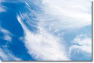
Weather Topic: What are Altostratus Clouds?
Home - Education - Cloud Types - Altostratus Clouds
 Next Topic: Cirrocumulus Clouds
Altostratus clouds form at mid to high-level altitudes
(between 2 and 7 km) and are created by a warm, stable air mass which causes
water vapor
to condense as it rise through the atmosphere. Usually altostratus clouds are
featureless sheets characterized by a uniform color.
In some cases, wind punching through the cloud formation may give it a waved
appearance, called altostratus undulatus. Altostratus clouds
are commonly seen with other cloud formations accompanying them.
Next Topic: Cirrocumulus Clouds
Current conditions powered by WeatherAPI.com


