Weather Alert in West Virginia
Winter Storm Warning issued February 21 at 10:28PM EST until February 24 at 1:00AM EST by NWS Charleston WV
AREAS AFFECTED: Jackson; Lincoln; Putnam; Kanawha; Roane; Wirt; Calhoun; Ritchie; Doddridge; Mingo; Logan; Boone; Gilmer; Harrison; McDowell; Wyoming; Southeast Pocahontas
DESCRIPTION: * WHAT...Heavy snow expected. Total snow accumulations between 3 and 5 inches. Winds gusting as high as 35 mph. * WHERE...Portions of central, northeast, northern, and southern West Virginia. * WHEN...Until 1 AM EST Tuesday. * IMPACTS...Roads, and especially bridges and overpasses, will likely become slick and hazardous. Plan on slippery road conditions. The hazardous conditions could impact the Monday morning and evening commutes.
INSTRUCTION: Persons are urged to stay indoors until conditions improve. If you must go outside, dress in layers. Several layers of clothes will keep you warmer than a single heavy coat. Persons should delay all travel if possible. If travel is absolutely necessary, drive with extreme caution and be prepared for sudden changes in visibility. Leave plenty of room between you and the motorist ahead of you, and allow extra time to reach your destination. Avoid sudden braking or acceleration, and be especially cautious on hills or when making turns. Make sure your car is winterized and in good working order. Additional information can be found at https://www.weather.gov/rlx as well as on our X and Facebook pages.
Want more detail? Get the Complete 7 Day and Night Detailed Forecast!
Current U.S. National Radar--Current
The Current National Weather Radar is shown below with a UTC Time (subtract 5 hours from UTC to get Eastern Time).

National Weather Forecast--Current
The Current National Weather Forecast and National Weather Map are shown below.

National Weather Forecast for Tomorrow
Tomorrow National Weather Forecast and Tomorrow National Weather Map are show below.

North America Water Vapor (Moisture)
This map shows recent moisture content over North America. Bright and colored areas show high moisture (ie, clouds); brown indicates very little moisture present; black indicates no moisture.

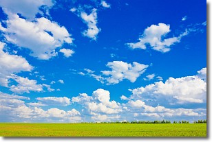
Weather Topic: What are Cumulus Clouds?
Home - Education - Cloud Types - Cumulus Clouds
 Next Topic: Drizzle
Cumulus clouds are fluffy and textured with rounded tops, and
may have flat bottoms. The border of a cumulus cloud
is clearly defined, and can have the appearance of cotton or cauliflower.
Cumulus clouds form at low altitudes (rarely above 2 km) but can grow very tall,
becoming cumulus congestus and possibly the even taller cumulonimbus clouds.
When cumulus clouds become taller, they have a greater chance of producing precipitation.
Next Topic: Drizzle
Weather Topic: What is Evaporation?
Home - Education - Precipitation - Evaporation
 Next Topic: Fog
Evaporation is the process which returns water from the earth
back to the atmosphere, and is another crucial process in the water cycle.
Evaporation is the transformation of liquid into gas, and it happens because
molecules are excited by the application of energy and turn into vapor.
In order for water to evaporate it has to be on the surface of a body of water.
Next Topic: Fog
Current conditions powered by WeatherAPI.com


