Weather Alert in Indiana
Flood Watch issued March 4 at 11:22AM EST until March 5 at 1:00PM EST by NWS Wilmington OH
AREAS AFFECTED: Wayne; Fayette; Union; Franklin; Ripley; Dearborn; Ohio; Switzerland; Carroll; Gallatin; Boone; Kenton; Campbell; Preble; Montgomery; Greene; Fayette; Pickaway; Butler; Warren; Clinton; Ross; Hocking; Hamilton; Clermont; Brown; Highland; Pike
DESCRIPTION: * WHAT...Flooding caused by excessive rainfall continues to be possible. * WHERE...The following counties, in Indiana, Dearborn, Fayette, Franklin, Ohio, Ripley, Switzerland, Union and Wayne, the following counties, in northern Kentucky, Boone, Campbell, Carroll, Gallatin and Kenton, and the following counties, in Ohio, Brown, Butler, Clermont, Clinton, Fayette, Greene, Hamilton, Highland, Hocking, Montgomery, Pickaway, Pike, Preble, Ross and Warren. * WHEN...Through Thursday afternoon. * IMPACTS...Soils remain moist and excessive runoff may result in flooding of rivers, creeks, streams, and other low-lying and flood-prone locations. * ADDITIONAL DETAILS... - While there has been in a lull in rainfall, showers and some thunderstorms will move back into the region later this afternoon and continue into tonight and Thursday morning. Additional rainfall of 1 to 2 inches with locally higher amounts is possible. With much of the area saturated from rainfall over the past day, this additional rain may quickly result in flooding.
INSTRUCTION: You should monitor later forecasts and be alert for possible Flood Warnings. Those living in areas prone to flooding should be prepared to take action should flooding develop.
Want more detail? Get the Complete 7 Day and Night Detailed Forecast!
Current U.S. National Radar--Current
The Current National Weather Radar is shown below with a UTC Time (subtract 5 hours from UTC to get Eastern Time).

National Weather Forecast--Current
The Current National Weather Forecast and National Weather Map are shown below.

National Weather Forecast for Tomorrow
Tomorrow National Weather Forecast and Tomorrow National Weather Map are show below.

North America Water Vapor (Moisture)
This map shows recent moisture content over North America. Bright and colored areas show high moisture (ie, clouds); brown indicates very little moisture present; black indicates no moisture.

Weather Topic: What is Hail?
Home - Education - Precipitation - Hail
 Next Topic: Hole Punch Clouds
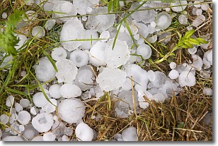
Hail is a form of precipitation which is recognized by large solid balls or
clumps of ice. Hail is created by thunderstorm clouds with strong updrafts of wind.
As the hailstones remain in the updraft, ice is deposited onto them until their
weight becomes heavy enough for them to fall to the earth's surface.
Hail storms can cause significant damage to crops, aircrafts, and man-made structures,
despite the fact that the duration is usually less than ten minutes.
Next Topic: Hole Punch Clouds
Weather Topic: What are Mammatus Clouds?
Home - Education - Cloud Types - Mammatus Clouds
 Next Topic: Nimbostratus Clouds
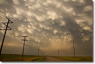
A mammatus cloud is a cloud with a unique feature which resembles
a web of pouches hanging along the base of the cloud.
In the United States, mammatus clouds tend to form in the warmer months, commonly
in the Midwest and eastern regions.
While they usually form at the bottom of a cumulonimbis cloud, they can also form
under altostratus, altocumulus, stratocumulus, and cirrus clouds. Mammatus clouds
warn that severe weather is close.
Next Topic: Nimbostratus Clouds
Current conditions powered by WeatherAPI.com


