Weather Alert in Minnesota
Snow Squall Warning issued February 27 at 2:31PM CST until February 27 at 3:00PM CST by NWS Grand Forks ND
AREAS AFFECTED: Mahnomen, MN; Norman, MN; Polk, MN; Red Lake, MN; Grand Forks, ND
DESCRIPTION: At 230 PM CST, a dangerous snow squall was located along a line extending from near Mekinock to near Climax to near Rindal, moving south at 25 mph. HAZARD...Flash freeze on roads. Intense bursts of heavy snow. Gusty winds leading to blowing snow and visibility rapidly falling to less than one-quarter mile. Wind gusts greater than 35 mph. SOURCE...Radar and webcams. IMPACT...Dangerous and life-threatening travel conditions are expected to develop rapidly in the warning area. This includes Interstate 29 between mile markers 129 and 157. Locations impacted include... Grand Forks, East Grand Forks, Crookston, Thompson, Fertile, Erskine, and Fisher.
INSTRUCTION: Wet roadways will quickly freeze. Black ice will cause roads, bridges, and overpasses to become slick and dangerous. Slow down and be prepared for a sudden loss of traction. Consider avoiding or delaying travel until the snow squall passes your location. If you must travel, use extra caution and allow extra time. Rapid changes in visibility and slick road conditions may lead to accidents.
Want more detail? Get the Complete 7 Day and Night Detailed Forecast!
Current U.S. National Radar--Current
The Current National Weather Radar is shown below with a UTC Time (subtract 5 hours from UTC to get Eastern Time).

National Weather Forecast--Current
The Current National Weather Forecast and National Weather Map are shown below.

National Weather Forecast for Tomorrow
Tomorrow National Weather Forecast and Tomorrow National Weather Map are show below.

North America Water Vapor (Moisture)
This map shows recent moisture content over North America. Bright and colored areas show high moisture (ie, clouds); brown indicates very little moisture present; black indicates no moisture.

Weather Topic: What are Cirrus Clouds?
Home - Education - Cloud Types - Cirrus Clouds
 Next Topic: Condensation
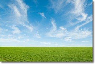
Cirrus clouds are high-level clouds that occur above 20,000 feet
and are composed mainly of ice crystals.
They are thin and wispy in appearance.
What do they indicate?
They are often the first sign of an approaching storm.
Next Topic: Condensation
Weather Topic: What are Contrails?
Home - Education - Cloud Types - Contrails
 Next Topic: Cumulonimbus Clouds
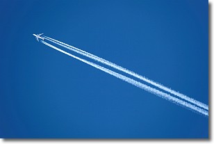
A contrail is an artificial cloud, created by the passing of an
aircraft.
Contrails form because water vapor in the exhaust of aircraft engines is suspended
in the air under certain temperatures and humidity conditions. These contrails
are called exhaust contrails.
Another type of contrail can form due to a temporary reduction in air pressure
moving over the plane's surface, causing condensation.
These are called aerodynamic contrails.
When you can see your breath on a cold day, it is also because of condensation.
The reason contrails last longer than the condensation from your breath is
because the water in contrails freezes into ice particles.
Next Topic: Cumulonimbus Clouds
Current conditions powered by WeatherAPI.com


