Weather Alert in Alaska
Winter Weather Advisory issued February 21 at 10:27AM AKST until February 25 at 3:00PM AKST by NWS Fairbanks AK
AREAS AFFECTED: Upper Tanana Valley; Delta Junction; Eastern Alaska Range North of Trims Camp
DESCRIPTION: * WHAT...Snow and blowing snow expected. Total snow accumulations between 4 and 7 inches. Winds gusting as high as 40 mph. Areas of blowing snow may reduce visibility to 1/2 mile or less at times. * WHERE...Delta Junction, Eastern Alaska Range North of Trims Camp, and Upper Tanana Valley. * WHEN...From noon Sunday to 3 PM AKST Wednesday. * IMPACTS...Travel could be very difficult. * ADDITIONAL DETAILS...Multiple days of light snow expected. Northwesterly winds increase late Monday into Tuesday increasing the chances of blowing snow hazards.
INSTRUCTION: Slow down and use caution while traveling. Visit 511.alaska.gov or call 5 1 1 for the latest road conditions.
Want more detail? Get the Complete 7 Day and Night Detailed Forecast!
Current U.S. National Radar--Current
The Current National Weather Radar is shown below with a UTC Time (subtract 5 hours from UTC to get Eastern Time).

National Weather Forecast--Current
The Current National Weather Forecast and National Weather Map are shown below.

National Weather Forecast for Tomorrow
Tomorrow National Weather Forecast and Tomorrow National Weather Map are show below.

North America Water Vapor (Moisture)
This map shows recent moisture content over North America. Bright and colored areas show high moisture (ie, clouds); brown indicates very little moisture present; black indicates no moisture.

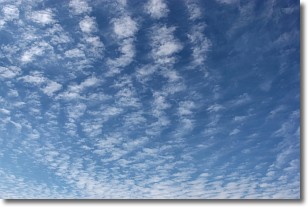
Weather Topic: What are Altocumulus Clouds?
Home - Education - Cloud Types - Altocumulus Clouds
 Next Topic: Altostratus Clouds
Similar to cirrocumulus clouds, altocumulus clouds are
characterized by cloud patches. They are distinguished by larger cloudlets
than cirrocumulus clouds but are still smaller than stratocumulus clouds.
Altocumulus clouds most commonly form in middle altitudes (between 2 and 5 km)
and may resemble, at times, the shape of a flying saucer.
These uncommon formations, called altocumulus lenticularis, are created by uplift
in the atmosphere and are most often seen in close proximity to mountains.
Next Topic: Altostratus Clouds
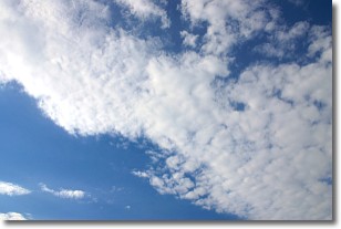
Weather Topic: What are Cirrocumulus Clouds?
Home - Education - Cloud Types - Cirrocumulus Clouds
 Next Topic: Cirrostratus Clouds
Cirrocumulus clouds form at high altitudes (usually around 5 km)
and have distinguishing characteristics displayed in a fine layer of
small cloud patches. These small cloud patches are sometimes referred to as
"cloudlets" in relation to the whole cloud formation.
Cirrocumulus clouds are formed from ice crystals and water droplets. Often, the
water droplets in the cloud freeze into ice crystals and the cloud becomes a
cirrostratus cloud. Because of this common occurrence, cirrocumulus cloud
formations generally pass rapidly.
Next Topic: Cirrostratus Clouds
Current conditions powered by WeatherAPI.com


