Weather Alert in Texas
Fire Weather Watch issued February 24 at 12:51PM CST until February 25 at 6:00PM CST by NWS Brownsville TX
AREAS AFFECTED: Zapata; Jim Hogg; Brooks; Inland Kenedy; Starr; Southern Hidalgo; Inland Willacy; Inland Cameron; Northern Hidalgo
DESCRIPTION: ......ELEVATED FIRE WEATHER CONDITIONS POSSIBLE ACROSS INLAND DEEP SOUTH TEXAS ON WEDNESDAY...... .An approaching front brings gusty southerly winds and dry air into tomorrow. Dry air in place Wednesday with gusty winds warrants possible Fire Danger Statements and/or Red Flag Warnings. The National Weather Service in Brownsville has issued a Fire Weather Watch for Zapata, Jim Hogg, Brooks, Inland Kenedy, Starr, Hidalgo, Inland Willacy, and Inland Cameron counties, which is in effect Wednesday afternoon. * AFFECTED AREA...Zapata, Jim Hogg, Brooks, Inland Kenedy, Starr, Hidalgo, Inland Willacy, and Inland Cameron counties. * TIMING...Through Wednesday afternoon. * WINDS...Southerly 10 to 25 mph with gusts around 35 mph. * RELATIVE HUMIDITY...As low as 19 percent. * TEMPERATURES...85-94. * IMPACTS...Any fire that develops will catch and spread quickly. Outdoor burning is not recommended.
INSTRUCTION: A Fire Weather Watch means that critical fire weather conditions are forecast to occur. Listen for later forecasts and possible Red Flag Warnings.
Want more detail? Get the Complete 7 Day and Night Detailed Forecast!
Current U.S. National Radar--Current
The Current National Weather Radar is shown below with a UTC Time (subtract 5 hours from UTC to get Eastern Time).

National Weather Forecast--Current
The Current National Weather Forecast and National Weather Map are shown below.

National Weather Forecast for Tomorrow
Tomorrow National Weather Forecast and Tomorrow National Weather Map are show below.

North America Water Vapor (Moisture)
This map shows recent moisture content over North America. Bright and colored areas show high moisture (ie, clouds); brown indicates very little moisture present; black indicates no moisture.

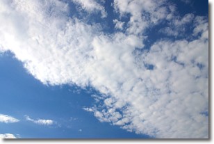
Weather Topic: What are Altocumulus Clouds?
Home - Education - Cloud Types - Altocumulus Clouds
 Next Topic: Altostratus Clouds
Similar to cirrocumulus clouds, altocumulus clouds are
characterized by cloud patches. They are distinguished by larger cloudlets
than cirrocumulus clouds but are still smaller than stratocumulus clouds.
Altocumulus clouds most commonly form in middle altitudes (between 2 and 5 km)
and may resemble, at times, the shape of a flying saucer.
These uncommon formations, called altocumulus lenticularis, are created by uplift
in the atmosphere and are most often seen in close proximity to mountains.
Next Topic: Altostratus Clouds
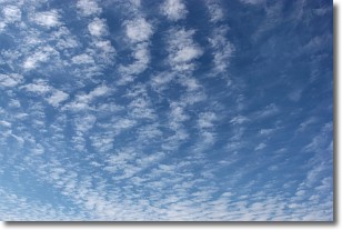
Weather Topic: What are Cirrocumulus Clouds?
Home - Education - Cloud Types - Cirrocumulus Clouds
 Next Topic: Cirrostratus Clouds
Cirrocumulus clouds form at high altitudes (usually around 5 km)
and have distinguishing characteristics displayed in a fine layer of
small cloud patches. These small cloud patches are sometimes referred to as
"cloudlets" in relation to the whole cloud formation.
Cirrocumulus clouds are formed from ice crystals and water droplets. Often, the
water droplets in the cloud freeze into ice crystals and the cloud becomes a
cirrostratus cloud. Because of this common occurrence, cirrocumulus cloud
formations generally pass rapidly.
Next Topic: Cirrostratus Clouds
Current conditions powered by WeatherAPI.com


