Weather Alert in Texas
Red Flag Warning issued February 21 at 12:37PM CST until February 21 at 9:00PM CST by NWS Corpus Christi TX
AREAS AFFECTED: La Salle; McMullen; Live Oak; Bee; Goliad; Webb; Duval; Jim Wells
DESCRIPTION: ...CRITICAL FIRE WEATHER CONDITIONS SATURDAY... .Significantly drier air will move into the region behind a cold front mid-day today. Along with this, strong northerly winds will lead to critical fire weather conditions across the warned area. * AFFECTED AREA...La Salle, McMullen, Live Oak, Bee, Goliad, Webb, Duval and Jim Wells. * TIMING...This afternoon and early evening. * WINDS...North 15 to 20 mph with gusts up to 30 mph. * RELATIVE HUMIDITY...As low as 18 percent. * TEMPERATURES...Up to 82. * IMPACTS...Any fires that develop will likely spread rapidly. Outdoor burning is not recommended
INSTRUCTION: A Red Flag Warning means that critical fire weather conditions are either occurring now...or will shortly. A combination of strong winds...low relative humidity...and warm temperatures can contribute to extreme fire behavior. Residents are urged to exercise care with respect to all outdoor activities that could inadvertently cause wildfires. Report wildfires quickly to the nearest fire department or law enforcement office.
Want more detail? Get the Complete 7 Day and Night Detailed Forecast!
Current U.S. National Radar--Current
The Current National Weather Radar is shown below with a UTC Time (subtract 5 hours from UTC to get Eastern Time).

National Weather Forecast--Current
The Current National Weather Forecast and National Weather Map are shown below.

National Weather Forecast for Tomorrow
Tomorrow National Weather Forecast and Tomorrow National Weather Map are show below.

North America Water Vapor (Moisture)
This map shows recent moisture content over North America. Bright and colored areas show high moisture (ie, clouds); brown indicates very little moisture present; black indicates no moisture.

Weather Topic: What is Graupel?
Home - Education - Precipitation - Graupel
 Next Topic: Hail
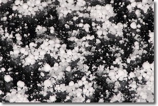
Graupel is a form of precipitation that is created by atmospheric conditions
which cause supercooled water droplets to contact snow crystals and freeze to
their surface.
Sometimes known as soft hail or snow pellets, graupel is delicate and easily
destroyed by touch. Whereas hail usually falls during severe weather, graupel
doesn't require such conditions to form, and can form in mild precipitation
similar to situations which produce snowfall.
Next Topic: Hail
Weather Topic: What are Hole Punch Clouds?
Home - Education - Cloud Types - Hole Punch Clouds
 Next Topic: Mammatus Clouds
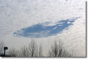
A hole punch cloud is an unusual occurrence when a disk-shaped
hole appears in a cirrostratus, cirrocumulus, or altocumulus cloud.
When part of the cloud forms ice crystals, water droplets in the surrounding area
of the cloud evaporate. The effect of this process produces a large elliptical
gap in the cloud. The hole punch cloud formation is rare, but it is not specific
to any geographic area.
Other names which have been used to describe this phenomena include fallstreak hole,
skypunch, and cloud hole.
Next Topic: Mammatus Clouds
Current conditions powered by WeatherAPI.com


