Weather Alert in Montana
Winter Weather Advisory issued March 5 at 12:31PM MST until March 6 at 9:00AM MST by NWS Billings MT
AREAS AFFECTED: Southern Rosebud; Southern Big Horn; Bighorn Canyon
DESCRIPTION: * WHAT...Snow expected. Total snow accumulations of up to 3 inches. * WHERE...Bighorn Canyon, Southern Big Horn, and Southern Rosebud. * WHEN...From 5 PM this afternoon to 9 AM MST Friday. * IMPACTS...Plan on slippery road conditions. The hazardous conditions will impact the Thursday evening and Friday morning commutes. * ADDITIONAL DETAILS...The greatest snowfall amounts will fall along the Bighorn Foothills and in the higher hills south of Sheridan. Locations such as the Lame Deer Divide and Aberdeen Hill will also see higher snow amounts.
INSTRUCTION: Slow down and use caution while traveling. For the latest road conditions, call 5 1 1.
Want more detail? Get the Complete 7 Day and Night Detailed Forecast!
Current U.S. National Radar--Current
The Current National Weather Radar is shown below with a UTC Time (subtract 5 hours from UTC to get Eastern Time).

National Weather Forecast--Current
The Current National Weather Forecast and National Weather Map are shown below.

National Weather Forecast for Tomorrow
Tomorrow National Weather Forecast and Tomorrow National Weather Map are show below.

North America Water Vapor (Moisture)
This map shows recent moisture content over North America. Bright and colored areas show high moisture (ie, clouds); brown indicates very little moisture present; black indicates no moisture.

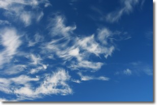
Weather Topic: What are Altostratus Clouds?
Home - Education - Cloud Types - Altostratus Clouds
 Next Topic: Cirrocumulus Clouds
Altostratus clouds form at mid to high-level altitudes
(between 2 and 7 km) and are created by a warm, stable air mass which causes
water vapor
to condense as it rise through the atmosphere. Usually altostratus clouds are
featureless sheets characterized by a uniform color.
In some cases, wind punching through the cloud formation may give it a waved
appearance, called altostratus undulatus. Altostratus clouds
are commonly seen with other cloud formations accompanying them.
Next Topic: Cirrocumulus Clouds
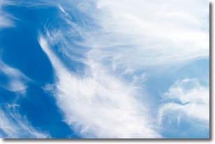
Weather Topic: What are Cirrostratus Clouds?
Home - Education - Cloud Types - Cirrostratus Clouds
 Next Topic: Cirrus Clouds
Cirrostratus clouds are high, thin clouds that form above
20,000 feet and are made mostly of ice crystals. They sometimes look like giant
feathers, horse tails, or curls of hair in the sky.
These clouds are pushed by the jet stream and can move at high speeds reaching
100 mph.
What do they indicate?
They indicate that a precipitation is likely within 24 hours.
Next Topic: Cirrus Clouds
Current conditions powered by WeatherAPI.com


