Weather Alert in Hawaii
High Surf Advisory issued February 23 at 3:30PM HST until February 24 at 6:00PM HST by NWS Honolulu HI
AREAS AFFECTED: Maui Leeward West; Kohala; Molokai West; Lanai Windward
DESCRIPTION: ...HIGH SURF WARNING FOR NORTH AND EAST FACING SHORES OF NIIHAU KAUAI OAHU MOLOKAI MAUI AND BIG ISLAND THROUGH TUESDAY... ...HIGH SURF ADVISORY FOR WEST FACING SHORES OF MOLOKAI MAUI AND BIG ISLAND AND FOR NORTH FACING SHORES OF LANAI THROUGH TUESDAY... .A long period north-northeast (010-030 degrees) swell will peak tonight and Tuesday, producing much larger than normal surf across some coastlines, especially in windward areas. The swell will gradually decline Tuesday night through Friday. * WHAT...Along west facing shores of the Big Island in the Kohala Districts, surf building to 6 to 10 feet tonight and continuing into Tuesday. Along west facing shores of Maui, surf building to 10 to 16 feet tonight and continuing into Tuesday. Along west facing shores of Molokai and north facing shores of Lanai, surf building to 10 to 16 feet tonight and continuing into Tuesday. * WHERE...West facing shores of Molokai, Maui, and Big Island and for north facing shores of Lanai. * WHEN...From 6 PM this evening to 6 PM HST Tuesday. * IMPACTS...Moderate. Strong breaking waves and strong currents will make swimming dangerous.
INSTRUCTION: Heed all advice from ocean safety officials. When in doubt, don't go out.
Want more detail? Get the Complete 7 Day and Night Detailed Forecast!
Current U.S. National Radar--Current
The Current National Weather Radar is shown below with a UTC Time (subtract 5 hours from UTC to get Eastern Time).

National Weather Forecast--Current
The Current National Weather Forecast and National Weather Map are shown below.

National Weather Forecast for Tomorrow
Tomorrow National Weather Forecast and Tomorrow National Weather Map are show below.

North America Water Vapor (Moisture)
This map shows recent moisture content over North America. Bright and colored areas show high moisture (ie, clouds); brown indicates very little moisture present; black indicates no moisture.

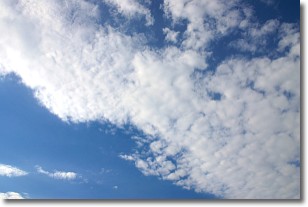
Weather Topic: What are Stratus Clouds?
Home - Education - Cloud Types - Stratus Clouds
 Next Topic: Wall Clouds
Stratus clouds are similar to altostratus clouds, but form at a
lower altitude and are identified by their fog-like appearance, lacking the
distinguishing features of most clouds.
Stratus clouds are wider than most clouds, and their base has a smooth, uniform
look which is lighter in color than a nimbostratus cloud.
The presence of a stratus cloud indicates the possibility of minor precipitation,
such as drizzle, but heavier precipitation does not typically arrive in the form
of a stratus cloud.
Next Topic: Wall Clouds
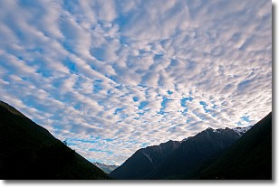
Weather Topic: What are Altocumulus Clouds?
Home - Education - Cloud Types - Altocumulus Clouds
 Next Topic: Altostratus Clouds
Similar to cirrocumulus clouds, altocumulus clouds are
characterized by cloud patches. They are distinguished by larger cloudlets
than cirrocumulus clouds but are still smaller than stratocumulus clouds.
Altocumulus clouds most commonly form in middle altitudes (between 2 and 5 km)
and may resemble, at times, the shape of a flying saucer.
These uncommon formations, called altocumulus lenticularis, are created by uplift
in the atmosphere and are most often seen in close proximity to mountains.
Next Topic: Altostratus Clouds
Current conditions powered by WeatherAPI.com


