Weather Alert in New Mexico
Red Flag Warning issued March 6 at 10:45AM MST until March 6 at 7:00PM MST by NWS El Paso Tx/Santa Teresa NM
AREAS AFFECTED: Capitan And Sacramento Mountains
DESCRIPTION: ...CRITICAL FIRE WEATHER CONDITIONS THIS AFTERNOON FOR THE CAPITAN AND SACRAMENTO MOUNTAINS... .Developing surface low over the OK/TX Panhandle will keep winds strong across eastern and southern New Mexico this afternoon. Winds out of the west 20 to 30 mph with gusts up to 45 mph are expected. These winds combined with low RH of 8 to 14% will create Near Critical fire weather conditions in the Sacramento Mountains and Lincoln National Forest. Conditions are expected to reach Red Flag criteria for a few hours this afternoon. While large fuels like timber are not currently susceptible to wildfire, fine fuels like grasses and brush are at higher risk. * AFFECTED AREA...Fire Weather Zone 113 Capitan and Sacramento Mountains/Lincoln NF/LNZ. * TIMING...10 AM TO 7 PM Friday. * WINDS...West 20 to 30 mph with gusts up to 45 mph. * RELATIVE HUMIDITY...8 to 14 percent. * RED FLAG THREAT INDEX...3 to 4, Near Critical. * IMPACTS...Any fires that develop will likely spread rapidly. Outdoor burning is not recommended.
INSTRUCTION: A Red Flag Warning means that critical fire weather conditions are either occurring now, or will shortly. A combination of strong winds, low relative humidity, and warm temperatures can contribute to extreme fire behavior.
Want more detail? Get the Complete 7 Day and Night Detailed Forecast!
Current U.S. National Radar--Current
The Current National Weather Radar is shown below with a UTC Time (subtract 5 hours from UTC to get Eastern Time).

National Weather Forecast--Current
The Current National Weather Forecast and National Weather Map are shown below.

National Weather Forecast for Tomorrow
Tomorrow National Weather Forecast and Tomorrow National Weather Map are show below.

North America Water Vapor (Moisture)
This map shows recent moisture content over North America. Bright and colored areas show high moisture (ie, clouds); brown indicates very little moisture present; black indicates no moisture.

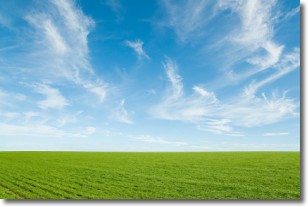
Weather Topic: What are Cirrus Clouds?
Home - Education - Cloud Types - Cirrus Clouds
 Next Topic: Condensation
Cirrus clouds are high-level clouds that occur above 20,000 feet
and are composed mainly of ice crystals.
They are thin and wispy in appearance.
What do they indicate?
They are often the first sign of an approaching storm.
Next Topic: Condensation
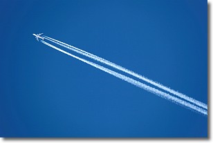
Weather Topic: What are Contrails?
Home - Education - Cloud Types - Contrails
 Next Topic: Cumulonimbus Clouds
A contrail is an artificial cloud, created by the passing of an
aircraft.
Contrails form because water vapor in the exhaust of aircraft engines is suspended
in the air under certain temperatures and humidity conditions. These contrails
are called exhaust contrails.
Another type of contrail can form due to a temporary reduction in air pressure
moving over the plane's surface, causing condensation.
These are called aerodynamic contrails.
When you can see your breath on a cold day, it is also because of condensation.
The reason contrails last longer than the condensation from your breath is
because the water in contrails freezes into ice particles.
Next Topic: Cumulonimbus Clouds
Current conditions powered by WeatherAPI.com


