Weather Alert in New Mexico
Red Flag Warning issued March 6 at 10:45AM MST until March 6 at 7:00PM MST by NWS El Paso Tx/Santa Teresa NM
AREAS AFFECTED: Capitan And Sacramento Mountains
DESCRIPTION: ...CRITICAL FIRE WEATHER CONDITIONS THIS AFTERNOON FOR THE CAPITAN AND SACRAMENTO MOUNTAINS... .Developing surface low over the OK/TX Panhandle will keep winds strong across eastern and southern New Mexico this afternoon. Winds out of the west 20 to 30 mph with gusts up to 45 mph are expected. These winds combined with low RH of 8 to 14% will create Near Critical fire weather conditions in the Sacramento Mountains and Lincoln National Forest. Conditions are expected to reach Red Flag criteria for a few hours this afternoon. While large fuels like timber are not currently susceptible to wildfire, fine fuels like grasses and brush are at higher risk. * AFFECTED AREA...Fire Weather Zone 113 Capitan and Sacramento Mountains/Lincoln NF/LNZ. * TIMING...10 AM TO 7 PM Friday. * WINDS...West 20 to 30 mph with gusts up to 45 mph. * RELATIVE HUMIDITY...8 to 14 percent. * RED FLAG THREAT INDEX...3 to 4, Near Critical. * IMPACTS...Any fires that develop will likely spread rapidly. Outdoor burning is not recommended.
INSTRUCTION: A Red Flag Warning means that critical fire weather conditions are either occurring now, or will shortly. A combination of strong winds, low relative humidity, and warm temperatures can contribute to extreme fire behavior.
Want more detail? Get the Complete 7 Day and Night Detailed Forecast!
Current U.S. National Radar--Current
The Current National Weather Radar is shown below with a UTC Time (subtract 5 hours from UTC to get Eastern Time).

National Weather Forecast--Current
The Current National Weather Forecast and National Weather Map are shown below.

National Weather Forecast for Tomorrow
Tomorrow National Weather Forecast and Tomorrow National Weather Map are show below.

North America Water Vapor (Moisture)
This map shows recent moisture content over North America. Bright and colored areas show high moisture (ie, clouds); brown indicates very little moisture present; black indicates no moisture.

Weather Topic: What are Fractus Clouds?
Home - Education - Cloud Types - Fractus Clouds
 Next Topic: Freezing Rain
A fractus cloud (scud) is a fragmented, tattered cloud which has
likely been sheared off of another cloud. They are accessory clouds, meaning they
develop from parent clouds, and are named in a way which describes the original
cloud which contained them.
Fractus clouds which have originated from cumulus clouds are referred to as
cumulus fractus, while fractus clouds which have originated from stratus clouds
are referred to as stratus fractus. Under certain conditions a fractus cloud might
merge with another cloud, or develop into a cumulus cloud, but usually a
fractus cloud seen by itself will dissipate rapidly.
They are often observed on the leading and trailing edges of storm clouds,
and are a display of wind activity.
Next Topic: Freezing Rain
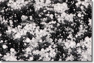
Weather Topic: What is Graupel?
Home - Education - Precipitation - Graupel
 Next Topic: Hail
Graupel is a form of precipitation that is created by atmospheric conditions
which cause supercooled water droplets to contact snow crystals and freeze to
their surface.
Sometimes known as soft hail or snow pellets, graupel is delicate and easily
destroyed by touch. Whereas hail usually falls during severe weather, graupel
doesn't require such conditions to form, and can form in mild precipitation
similar to situations which produce snowfall.
Next Topic: Hail
Current conditions powered by WeatherAPI.com


