Weather Alert in Montana
Avalanche Warning issued February 23 at 7:09AM MST by NWS Missoula MT
AREAS AFFECTED: Kootenai/Cabinet Region; West Glacier Region
DESCRIPTION: AVWMSO The following message is transmitted at the request of Flathead Avalanche Center Hungry Horse MT. ...AVALANCHE WARNING ISSUED BY THE FLATHEAD AVALANCHE CENTER... 06:30 MST Mon Feb 23 2026 The Flathead Avalanche Center in Hungry Horse has issued a BACKCOUNTRY AVALANCHE WARNING for the following areas: NWS Missoula MT - MTZ001 (MTZ001)...MTZ002 (MTZ002) * WHAT...Heavy snowfall rates and wind-drifted snow will create very dangerous avalanche conditions. * WHERE...Slopes above 5000 feet in the Whitefish, Swan and Flathead Ranges, and the Lake McDonald and Marias Pass areas of Glacier National Park.</p> * WHEN...In effect from Mon 06:30 MST to Tue 06:01 MST. * IMPACTS...Natural and human-triggered avalanches are very likely. Avalanches will release on weak layers buried 2 to 3+ feet deep. These will run long distances, travel into low-angle terrain, and can cover snowmobile trails. Avalanches may connect across terrain features like ridges, releasing multiple start zones at once. Avalanches can be triggered from long distances away. Smaller slopes, such as roadcuts, may also avalanche, depositing a surprising amount of debris on the road below. * PRECAUTIONARY / PREPAREDNESS ACTIONS...Very dangerous avalanche conditions. Pay close attention to the terrain around you. Avoid traveling on and under steep slopes. Consult http://www.flatheadavalanche.org/ or www.avalanche.org for more detailed information. Similar avalanche danger may exist at locations outside the coverage area of this or any avalanche center.
INSTRUCTION: N/A
Want more detail? Get the Complete 7 Day and Night Detailed Forecast!
Current U.S. National Radar--Current
The Current National Weather Radar is shown below with a UTC Time (subtract 5 hours from UTC to get Eastern Time).

National Weather Forecast--Current
The Current National Weather Forecast and National Weather Map are shown below.

National Weather Forecast for Tomorrow
Tomorrow National Weather Forecast and Tomorrow National Weather Map are show below.

North America Water Vapor (Moisture)
This map shows recent moisture content over North America. Bright and colored areas show high moisture (ie, clouds); brown indicates very little moisture present; black indicates no moisture.

Weather Topic: What is Condensation?
Home - Education - Precipitation - Condensation
 Next Topic: Contrails
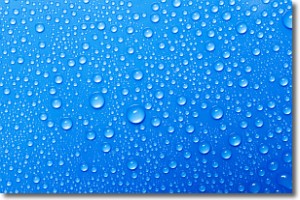
Condensation is the process which creates clouds, and therefore
it is a crucial process in the water cycle.
Condensation is the change of matter from a state of gas into a state of liquid,
and it happens because water molecules release heat into the atmosphere and
become organized into a more closely packed structure, what we might see as
water droplets.
Water is always present in the air around us as a vapor, but it's too small for
us to see. When water undergoes the process of condensation it becomes organized
into visible water droplets. You've probably seen condensation happen before on the
surface of a cold drink!
Next Topic: Contrails
Weather Topic: What are Cumulonimbus Clouds?
Home - Education - Cloud Types - Cumulonimbus Clouds
 Next Topic: Cumulus Clouds
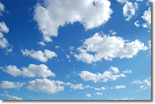
The final form taken by a growing cumulus cloud is the
cumulonimbus cloud, which is very tall and dense.
The tower of a cumulonimbus cloud can soar 23 km into the atmosphere, although
most commonly they stop growing at an altitude of 6 km.
Even small cumulonimbus clouds appear very large in comparison to other cloud types.
They can signal the approach of stormy weather, such as thunderstorms or blizzards.
Next Topic: Cumulus Clouds
Current conditions powered by WeatherAPI.com


