Weather Alert in North Carolina
Winter Storm Warning issued February 22 at 1:51AM EST until February 24 at 12:00AM EST by NWS Blacksburg VA
AREAS AFFECTED: Ashe; Watauga; Smyth; Grayson
DESCRIPTION: Low pressure will pass over the region today with rain changing to snow across the higher elevations. Arrival of colder air Sunday along with the development of a strong winter storm along the Mid-Atlantic coast will result in an extended period of snow showers and blustery winds across the mountains Sunday night through Monday night. * WHAT...Heavy snow mainly for elevations above 3500 Feet. Total snow Total accumulations ranging from up to 3 inches in the lower elevations, to 5 to 12 inches above 3500 feet, especially in places like Beech Mountain, Mount Rogers and Flattop Mountain. Winds gusting as high as 50 mph. * WHERE...In North Carolina, Ashe and Watauga Counties. In Virginia, Grayson and Smyth Counties. * WHEN...Until midnight EST Monday Night. * IMPACTS...Roads, and especially bridges and overpasses, will likely become slick and hazardous. Visibilities may drop below 1/4 mile due to falling and blowing snow. Travel could be very difficult. The hazardous conditions could impact the Monday morning and evening commutes. Gusty winds could bring down tree branches.
INSTRUCTION: If you must travel, keep an extra flashlight, food, and water in your vehicle in case of an emergency. The latest road conditions for the state you are calling from can be obtained by calling 5 1 1. Persons should consider delaying all travel. Motorists should use extreme caution if travel is absolutely necessary.
Want more detail? Get the Complete 7 Day and Night Detailed Forecast!
Current U.S. National Radar--Current
The Current National Weather Radar is shown below with a UTC Time (subtract 5 hours from UTC to get Eastern Time).

National Weather Forecast--Current
The Current National Weather Forecast and National Weather Map are shown below.

National Weather Forecast for Tomorrow
Tomorrow National Weather Forecast and Tomorrow National Weather Map are show below.

North America Water Vapor (Moisture)
This map shows recent moisture content over North America. Bright and colored areas show high moisture (ie, clouds); brown indicates very little moisture present; black indicates no moisture.

Weather Topic: What is Sleet?
Home - Education - Precipitation - Sleet
 Next Topic: Snow
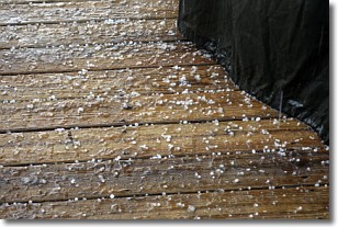
Sleet is a form of precipitation in which small ice pellets are the primary
components. These ice pellets are smaller and more translucent than hailstones,
and harder than graupel. Sleet is caused by specific atmospheric conditions and
therefore typically doesn't last for extended periods of time.
The condition which leads to sleet formation requires a warmer body of air to be
wedged in between two sub-freezing bodies of air. When snow falls through a warmer
layer of air it melts, and as it falls through the next sub-freezing body of air
it freezes again, forming ice pellets known as sleet. In some cases, water
droplets don't have time to freeze before reaching the surface and the result is
freezing rain.
Next Topic: Snow
Weather Topic: What are Stratocumulus Clouds?
Home - Education - Cloud Types - Stratocumulus Clouds
 Next Topic: Stratus Clouds
Stratocumulus clouds are similar to altocumulus clouds in their
fluffy appearance, but have a slightly darker shade due to their additional mass.
A good way to distinguish the two cloud types is to hold your hand out and measure
the size of an individual cloud; if it is the size of your thumb it is generally
an altocumulus cloud, if it is the size of your hand it is generally a
stratocumulus cloud.
It is uncommon for stratocumulus clouds to produce precipitation, but if they do
it is usually a light rain or snow.
Next Topic: Stratus Clouds
Current conditions powered by WeatherAPI.com


