Weather Alert in Louisiana
Red Flag Warning issued February 21 at 9:42PM CST until February 22 at 6:00PM CST by NWS Lake Charles LA
AREAS AFFECTED: Allen; Lafayette; East Cameron; Northern Calcasieu; Northern Jefferson Davis; Northern Acadia; Upper Vermilion; Southern Calcasieu; Southern Jefferson Davis; Southern Acadia; Lower Vermilion
DESCRIPTION: ...Fire weather warning in effect for Sunday... The National Weather Service in Lake Charles has issued a Red Flag Warning for low humidity, gusty winds and dry fuels, which is in effect from 9 AM to 6 PM CST Sunday. * AFFECTED AREA...Fire Weather Zone 031 Allen, Fire Weather Zone 044 Lafayette, Fire Weather Zone 074 East Cameron, Fire Weather Zone 141 Northern Calcasieu, Fire Weather Zone 142 Northern Jefferson Davis, Fire Weather Zone 143 Northern Acadia, Fire Weather Zone 152 Upper Vermilion, Fire Weather Zone 241 Southern Calcasieu, Fire Weather Zone 242 Southern Jefferson Davis, Fire Weather Zone 243 Southern Acadia and Fire Weather Zone 252 Lower Vermilion. * TIMING...From 9 AM to 6 PM CST Sunday. * WINDS...North 10 to 20 mph with gusts up to 30 mph. * RELATIVE HUMIDITY...As low as 24 percent. * TEMPERATURES...Up to 59. * LIGHTNING...None. * IMPACTS...Any fire that develops will catch and spread quickly. Outdoor burning is not recommended.
INSTRUCTION: A Red Flag Warning means that critical fire weather conditions are either occurring now, or will shortly. A combination of strong winds, low relative humidity, and warm temperatures can contribute to extreme fire behavior.
Want more detail? Get the Complete 7 Day and Night Detailed Forecast!
Current U.S. National Radar--Current
The Current National Weather Radar is shown below with a UTC Time (subtract 5 hours from UTC to get Eastern Time).

National Weather Forecast--Current
The Current National Weather Forecast and National Weather Map are shown below.

National Weather Forecast for Tomorrow
Tomorrow National Weather Forecast and Tomorrow National Weather Map are show below.

North America Water Vapor (Moisture)
This map shows recent moisture content over North America. Bright and colored areas show high moisture (ie, clouds); brown indicates very little moisture present; black indicates no moisture.

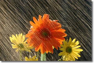
Weather Topic: What is Precipitation?
Home - Education - Precipitation - Precipitation
 Next Topic: Rain
Precipitation can refer to many different forms of water that
may fall from clouds. Precipitation occurs after a cloud has become saturated to
the point where its water particles are more dense than the air below the cloud.
In most cases, precipitation will reach the ground, but it is not uncommon for
precipitation to evaporate before it reaches the earth's surface.
When precipitation evaporates before it contacts the ground it is called Virga.
Graupel, hail, sleet, rain, drizzle, and snow are forms of precipitation, but fog
and mist are not considered precipitation because the water vapor which
constitutes them isn't dense enough to fall to the ground.
Next Topic: Rain
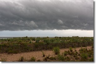
Weather Topic: What are Shelf Clouds?
Home - Education - Cloud Types - Shelf Clouds
 Next Topic: Sleet
A shelf cloud is similar to a wall cloud, but forms at the front
of a storm cloud, instead of at the rear, where wall clouds form.
A shelf cloud is caused by a series of events set into motion by the advancing
storm; first, cool air settles along the ground where precipitation has just fallen.
As the cool air is brought in, the warmer air is displaced, and rises above it,
because it is less dense. When the warmer air reaches the bottom of the storm cloud,
it begins to cool again, and the resulting condensation is a visible shelf cloud.
Next Topic: Sleet
Current conditions powered by WeatherAPI.com


