Weather Alert in Florida
Rip Current Statement Special Weather Statement
Red Flag Warning issued February 22 at 1:15AM EST until February 22 at 7:00PM EST by NWS Tallahassee FL
AREAS AFFECTED: Inland Franklin; Leon; Inland Jefferson; Madison; Inland Wakulla; Inland Taylor; Lafayette; Inland Dixie; Coastal Franklin; Coastal Jefferson; Coastal Wakulla; Coastal Taylor; Coastal Dixie; Southern Liberty
DESCRIPTION: ...RED FLAG WARNING IN EFFECT FOR THE FL BIG BEND THIS AFTERNOON AND EVENING DUE TO CRITICALLY LOW HUMIDITY AND GUSTY WINDS... .A very dry airmass and gusty northwest winds are on tap this afternoon and evening. Critically low relative humidity, along with strong winds and dry fuels from the ongoing drought, are expected to result in red flag conditions this afternoon and evening. * AFFECTED AREA...Fire weather zones 015, 017, 018, 019, 027, 028, 029, 034, 115, 118, 127, 128, 134, and 426. * WIND...Northwest winds 16 to 22 mph with gusts of 25 to 30 mph. * HUMIDITY...As low as 25 percent. * IMPACTS...Any fires that develop will likely spread rapidly. Outdoor burning is not recommended.
INSTRUCTION: A Red Flag Warning means that critical fire weather conditions are either occurring now, or will shortly. A combination of strong winds, low relative humidity, and warm temperatures can contribute to extreme fire behavior.
Want more detail? Get the Complete 7 Day and Night Detailed Forecast!
Current U.S. National Radar--Current
The Current National Weather Radar is shown below with a UTC Time (subtract 5 hours from UTC to get Eastern Time).

National Weather Forecast--Current
The Current National Weather Forecast and National Weather Map are shown below.

National Weather Forecast for Tomorrow
Tomorrow National Weather Forecast and Tomorrow National Weather Map are show below.

North America Water Vapor (Moisture)
This map shows recent moisture content over North America. Bright and colored areas show high moisture (ie, clouds); brown indicates very little moisture present; black indicates no moisture.

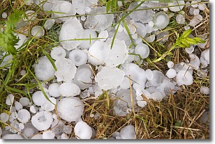
Weather Topic: What is Hail?
Home - Education - Precipitation - Hail
 Next Topic: Hole Punch Clouds
Hail is a form of precipitation which is recognized by large solid balls or
clumps of ice. Hail is created by thunderstorm clouds with strong updrafts of wind.
As the hailstones remain in the updraft, ice is deposited onto them until their
weight becomes heavy enough for them to fall to the earth's surface.
Hail storms can cause significant damage to crops, aircrafts, and man-made structures,
despite the fact that the duration is usually less than ten minutes.
Next Topic: Hole Punch Clouds
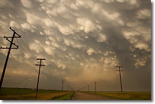
Weather Topic: What are Mammatus Clouds?
Home - Education - Cloud Types - Mammatus Clouds
 Next Topic: Nimbostratus Clouds
A mammatus cloud is a cloud with a unique feature which resembles
a web of pouches hanging along the base of the cloud.
In the United States, mammatus clouds tend to form in the warmer months, commonly
in the Midwest and eastern regions.
While they usually form at the bottom of a cumulonimbis cloud, they can also form
under altostratus, altocumulus, stratocumulus, and cirrus clouds. Mammatus clouds
warn that severe weather is close.
Next Topic: Nimbostratus Clouds
Current conditions powered by WeatherAPI.com


