Weather Alert in Montana
Winter Weather Advisory issued February 22 at 8:21PM MST until February 23 at 11:00AM MST by NWS Missoula MT
AREAS AFFECTED: Kootenai/Cabinet Region
DESCRIPTION: ...WINTRY MIX IN VALLEYS AND MOUNTAIN SNOW MONDAY THROUGH MONDAY NIGHT... .Snow levels will be borderline in northwest Montana valleys, and a wintry mix brings an increased risk for slick conditions during the Monday morning commute. Confidence is highest for accumulating snow across Lincoln County valley areas. Over mountain passes, snow will begin overnight with minor impacts, intensifying by Monday afternoon. Expect moderate travel impacts with slushy accumulation on I-90 and US-2 through Monday night. * WHAT...Snow expected. There is a likelihood of minor to moderate winter weather impacts. Total snow accumulations of 1 to 3 inches on Highway 93 Eureka to Whitefish and in the Yaak, with up to 1 inch elsewhere. * WHERE...Highway 93 Eureka to Whitefish, Highway 56 Bull Lake Road, Highway 37 Eureka to Libby, and Highway 2 Kalispell to Libby. * WHEN...Until 11 AM MST Monday. * IMPACTS...For MODERATE winter weather impacts, expect disruptions to normal activities. Hazardous traveling conditions. Use extra caution while driving. Closures and disruptions to infrastructure may occur. * ADDITIONAL DETAILS...An elevated risk exists for areas of black ice on Highway 93 south of Eureka and on Highway 2 east of Libby towards Kalispell.
INSTRUCTION: Slow down and use caution while traveling. The latest road conditions for the state you are calling from can be obtained by calling 5 1 1.
Want more detail? Get the Complete 7 Day and Night Detailed Forecast!
Current U.S. National Radar--Current
The Current National Weather Radar is shown below with a UTC Time (subtract 5 hours from UTC to get Eastern Time).

National Weather Forecast--Current
The Current National Weather Forecast and National Weather Map are shown below.

National Weather Forecast for Tomorrow
Tomorrow National Weather Forecast and Tomorrow National Weather Map are show below.

North America Water Vapor (Moisture)
This map shows recent moisture content over North America. Bright and colored areas show high moisture (ie, clouds); brown indicates very little moisture present; black indicates no moisture.

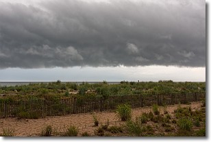
Weather Topic: What are Shelf Clouds?
Home - Education - Cloud Types - Shelf Clouds
 Next Topic: Sleet
A shelf cloud is similar to a wall cloud, but forms at the front
of a storm cloud, instead of at the rear, where wall clouds form.
A shelf cloud is caused by a series of events set into motion by the advancing
storm; first, cool air settles along the ground where precipitation has just fallen.
As the cool air is brought in, the warmer air is displaced, and rises above it,
because it is less dense. When the warmer air reaches the bottom of the storm cloud,
it begins to cool again, and the resulting condensation is a visible shelf cloud.
Next Topic: Sleet
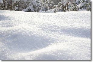
Weather Topic: What is Snow?
Home - Education - Precipitation - Snow
 Next Topic: Stratocumulus Clouds
Snow is precipitation taking the form of ice crystals. Each ice crystal, or snowflake,
has unique characteristics, but all of them grow in a hexagonal structure.
Snowfall can last for sustained periods of time and result in significant buildup
of snow on the ground.
On the earth's surface, snow starts out light and powdery, but as it begins to melt
it tends to become more granular, producing small bits of ice which have the consistency of
sand. After several cycles of melting and freezing, snow can become very dense
and ice-like, commonly known as snow pack.
Next Topic: Stratocumulus Clouds
Current conditions powered by WeatherAPI.com


