Weather Alert in California
Flood Watch issued February 21 at 11:40PM PST until February 25 at 12:00AM PST by NWS Eureka CA
AREAS AFFECTED: Coastal Del Norte; Del Norte Interior; Northern Humboldt Coast; Southwestern Humboldt; Northern Humboldt Interior; Southern Humboldt Interior; Northern Trinity; Southern Trinity; Mendocino Coast; Northwestern Mendocino Interior; Northeastern Mendocino Interior; Southwestern Mendocino Interior; Southeastern Mendocino Interior; Northern Lake County; Southern Lake County
DESCRIPTION: * WHAT...Flooding caused by excessive rainfall is possible. * WHERE...A portion of northwest California, including the following areas, Coastal Del Norte, Del Norte Interior, Mendocino Coast, Northeastern Mendocino Interior, Northern Humboldt Coast, Northern Humboldt Interior, Northern Lake, Northern Trinity, Northwestern Mendocino Interior, Southeastern Mendocino Interior, Southern Humboldt Interior, Southern Lake, Southern Trinity, Southwestern Humboldt and Southwestern Mendocino Interior. * WHEN...From Monday evening through Tuesday evening. * IMPACTS...There will be an increased risk of rock and land slides along roadways. Excessive runoff may result in flooding of rivers, creeks, streams, and other low-lying and flood-prone locations. * ADDITIONAL DETAILS... - A prolonged duration of moderate to heavy rain is expected. - http://www.weather.gov/safety/flood
INSTRUCTION: You should monitor later forecasts and be alert for possible Flood Warnings. Those living in areas prone to flooding should be prepared to take action should flooding develop.
Want more detail? Get the Complete 7 Day and Night Detailed Forecast!
Current U.S. National Radar--Current
The Current National Weather Radar is shown below with a UTC Time (subtract 5 hours from UTC to get Eastern Time).

National Weather Forecast--Current
The Current National Weather Forecast and National Weather Map are shown below.

National Weather Forecast for Tomorrow
Tomorrow National Weather Forecast and Tomorrow National Weather Map are show below.

North America Water Vapor (Moisture)
This map shows recent moisture content over North America. Bright and colored areas show high moisture (ie, clouds); brown indicates very little moisture present; black indicates no moisture.

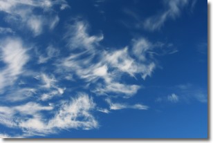
Weather Topic: What are Altostratus Clouds?
Home - Education - Cloud Types - Altostratus Clouds
 Next Topic: Cirrocumulus Clouds
Altostratus clouds form at mid to high-level altitudes
(between 2 and 7 km) and are created by a warm, stable air mass which causes
water vapor
to condense as it rise through the atmosphere. Usually altostratus clouds are
featureless sheets characterized by a uniform color.
In some cases, wind punching through the cloud formation may give it a waved
appearance, called altostratus undulatus. Altostratus clouds
are commonly seen with other cloud formations accompanying them.
Next Topic: Cirrocumulus Clouds
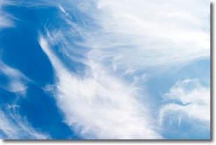
Weather Topic: What are Cirrostratus Clouds?
Home - Education - Cloud Types - Cirrostratus Clouds
 Next Topic: Cirrus Clouds
Cirrostratus clouds are high, thin clouds that form above
20,000 feet and are made mostly of ice crystals. They sometimes look like giant
feathers, horse tails, or curls of hair in the sky.
These clouds are pushed by the jet stream and can move at high speeds reaching
100 mph.
What do they indicate?
They indicate that a precipitation is likely within 24 hours.
Next Topic: Cirrus Clouds
Current conditions powered by WeatherAPI.com


