Weather Alert in California
Flood Watch issued February 21 at 11:40PM PST until February 25 at 12:00AM PST by NWS Eureka CA
AREAS AFFECTED: Coastal Del Norte; Del Norte Interior; Northern Humboldt Coast; Southwestern Humboldt; Northern Humboldt Interior; Southern Humboldt Interior; Northern Trinity; Southern Trinity; Mendocino Coast; Northwestern Mendocino Interior; Northeastern Mendocino Interior; Southwestern Mendocino Interior; Southeastern Mendocino Interior; Northern Lake County; Southern Lake County
DESCRIPTION: * WHAT...Flooding caused by excessive rainfall is possible. * WHERE...A portion of northwest California, including the following areas, Coastal Del Norte, Del Norte Interior, Mendocino Coast, Northeastern Mendocino Interior, Northern Humboldt Coast, Northern Humboldt Interior, Northern Lake, Northern Trinity, Northwestern Mendocino Interior, Southeastern Mendocino Interior, Southern Humboldt Interior, Southern Lake, Southern Trinity, Southwestern Humboldt and Southwestern Mendocino Interior. * WHEN...From Monday evening through Tuesday evening. * IMPACTS...There will be an increased risk of rock and land slides along roadways. Excessive runoff may result in flooding of rivers, creeks, streams, and other low-lying and flood-prone locations. * ADDITIONAL DETAILS... - A prolonged duration of moderate to heavy rain is expected. - http://www.weather.gov/safety/flood
INSTRUCTION: You should monitor later forecasts and be alert for possible Flood Warnings. Those living in areas prone to flooding should be prepared to take action should flooding develop.
Want more detail? Get the Complete 7 Day and Night Detailed Forecast!
Current U.S. National Radar--Current
The Current National Weather Radar is shown below with a UTC Time (subtract 5 hours from UTC to get Eastern Time).

National Weather Forecast--Current
The Current National Weather Forecast and National Weather Map are shown below.

National Weather Forecast for Tomorrow
Tomorrow National Weather Forecast and Tomorrow National Weather Map are show below.

North America Water Vapor (Moisture)
This map shows recent moisture content over North America. Bright and colored areas show high moisture (ie, clouds); brown indicates very little moisture present; black indicates no moisture.

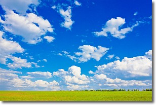
Weather Topic: What are Cumulus Clouds?
Home - Education - Cloud Types - Cumulus Clouds
 Next Topic: Drizzle
Cumulus clouds are fluffy and textured with rounded tops, and
may have flat bottoms. The border of a cumulus cloud
is clearly defined, and can have the appearance of cotton or cauliflower.
Cumulus clouds form at low altitudes (rarely above 2 km) but can grow very tall,
becoming cumulus congestus and possibly the even taller cumulonimbus clouds.
When cumulus clouds become taller, they have a greater chance of producing precipitation.
Next Topic: Drizzle
Weather Topic: What is Evaporation?
Home - Education - Precipitation - Evaporation
 Next Topic: Fog
Evaporation is the process which returns water from the earth
back to the atmosphere, and is another crucial process in the water cycle.
Evaporation is the transformation of liquid into gas, and it happens because
molecules are excited by the application of energy and turn into vapor.
In order for water to evaporate it has to be on the surface of a body of water.
Next Topic: Fog
Current conditions powered by WeatherAPI.com


