Weather Alert in California
Flood Watch issued February 21 at 11:40PM PST until February 25 at 12:00AM PST by NWS Eureka CA
AREAS AFFECTED: Coastal Del Norte; Del Norte Interior; Northern Humboldt Coast; Southwestern Humboldt; Northern Humboldt Interior; Southern Humboldt Interior; Northern Trinity; Southern Trinity; Mendocino Coast; Northwestern Mendocino Interior; Northeastern Mendocino Interior; Southwestern Mendocino Interior; Southeastern Mendocino Interior; Northern Lake County; Southern Lake County
DESCRIPTION: * WHAT...Flooding caused by excessive rainfall is possible. * WHERE...A portion of northwest California, including the following areas, Coastal Del Norte, Del Norte Interior, Mendocino Coast, Northeastern Mendocino Interior, Northern Humboldt Coast, Northern Humboldt Interior, Northern Lake, Northern Trinity, Northwestern Mendocino Interior, Southeastern Mendocino Interior, Southern Humboldt Interior, Southern Lake, Southern Trinity, Southwestern Humboldt and Southwestern Mendocino Interior. * WHEN...From Monday evening through Tuesday evening. * IMPACTS...There will be an increased risk of rock and land slides along roadways. Excessive runoff may result in flooding of rivers, creeks, streams, and other low-lying and flood-prone locations. * ADDITIONAL DETAILS... - A prolonged duration of moderate to heavy rain is expected. - http://www.weather.gov/safety/flood
INSTRUCTION: You should monitor later forecasts and be alert for possible Flood Warnings. Those living in areas prone to flooding should be prepared to take action should flooding develop.
Want more detail? Get the Complete 7 Day and Night Detailed Forecast!
Current U.S. National Radar--Current
The Current National Weather Radar is shown below with a UTC Time (subtract 5 hours from UTC to get Eastern Time).

National Weather Forecast--Current
The Current National Weather Forecast and National Weather Map are shown below.

National Weather Forecast for Tomorrow
Tomorrow National Weather Forecast and Tomorrow National Weather Map are show below.

North America Water Vapor (Moisture)
This map shows recent moisture content over North America. Bright and colored areas show high moisture (ie, clouds); brown indicates very little moisture present; black indicates no moisture.

Weather Topic: What is Drizzle?
Home - Education - Precipitation - Drizzle
 Next Topic: Evaporation
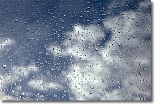
Drizzle is precipitation in the form of water droplets which are
smaller than raindrops.
Drizzle is characterized by fine, gently falling droplets and typically does not
impact human habitation in a negative way. The exception to this is freezing drizzle,
a condition where drizzle freezes immediately upon reaching earth's surface.
Freezing drizzle is still less dangerous than freezing rain, but can
potentially result in hazardous road conditions.
Next Topic: Evaporation
Weather Topic: What is Fog?
Home - Education - Cloud Types - Fog
 Next Topic: Fractus Clouds
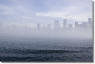
Fog is technically a type of stratus cloud, which lies along the
ground and obscures visibility.
It is usually created when humidity in the air condenses into tiny water droplets.
Because of this, some places are more prone to foggy weather, such as regions
close to a body of water.
Fog is similar to mist; both are the appearance of water droplets suspended in
the air, but fog is the term applied to the condition when visibility is less than 1 km.
Next Topic: Fractus Clouds
Current conditions powered by WeatherAPI.com


