Weather Alert in Pennsylvania
Winter Storm Warning issued February 22 at 9:41PM EST until February 23 at 6:00PM EST by NWS Mount Holly NJ
AREAS AFFECTED: Berks; Lehigh; Northampton
DESCRIPTION: ...A MAJOR WINTER STORM WILL CONTINUE TO IMPACT THE REGION THROUGH MONDAY... .A major winter storm will continue to impact the region through Monday. Very heavy snowfall and areas of blizzard conditions are expected. Moderate to heavy snowfall with rates of 1 to 2 inches per hour or more will persist overnight and into Monday morning. The heavy, wet snow will stick to trees and power lines, resulting in scattered tree damage and power outages. Record breaking snowfall totals are possible. * WHAT...Heavy snow. Additional snow accumulations between 4 and 12 inches. Winds gusting as high as 40 mph. * WHERE...Berks, Lehigh, and Northampton Counties. * WHEN...Until 6 PM EST Monday. * IMPACTS...Travel could be very difficult to impossible. Areas of blowing snow could significantly reduce visibility. The hazardous conditions will impact the Monday morning and evening commutes. Gusty winds could bring down tree branches and result in isolated power outages. * ADDITIONAL DETAILS...Snowfall rates could exceed 1 inch per hour. Locally higher snowfall amounts possible. Blowing and drifting of snow, and whiteout conditions possible.
INSTRUCTION: If you must travel, keep an extra flashlight, food, and water in your vehicle in case of an emergency. The latest road conditions for the state you are calling from can be obtained by calling 5 1 1.
Want more detail? Get the Complete 7 Day and Night Detailed Forecast!
Current U.S. National Radar--Current
The Current National Weather Radar is shown below with a UTC Time (subtract 5 hours from UTC to get Eastern Time).

National Weather Forecast--Current
The Current National Weather Forecast and National Weather Map are shown below.

National Weather Forecast for Tomorrow
Tomorrow National Weather Forecast and Tomorrow National Weather Map are show below.

North America Water Vapor (Moisture)
This map shows recent moisture content over North America. Bright and colored areas show high moisture (ie, clouds); brown indicates very little moisture present; black indicates no moisture.

Weather Topic: What is Graupel?
Home - Education - Precipitation - Graupel
 Next Topic: Hail
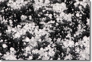
Graupel is a form of precipitation that is created by atmospheric conditions
which cause supercooled water droplets to contact snow crystals and freeze to
their surface.
Sometimes known as soft hail or snow pellets, graupel is delicate and easily
destroyed by touch. Whereas hail usually falls during severe weather, graupel
doesn't require such conditions to form, and can form in mild precipitation
similar to situations which produce snowfall.
Next Topic: Hail
Weather Topic: What are Hole Punch Clouds?
Home - Education - Cloud Types - Hole Punch Clouds
 Next Topic: Mammatus Clouds
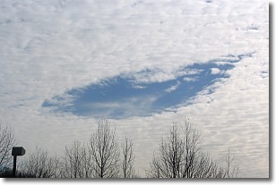
A hole punch cloud is an unusual occurrence when a disk-shaped
hole appears in a cirrostratus, cirrocumulus, or altocumulus cloud.
When part of the cloud forms ice crystals, water droplets in the surrounding area
of the cloud evaporate. The effect of this process produces a large elliptical
gap in the cloud. The hole punch cloud formation is rare, but it is not specific
to any geographic area.
Other names which have been used to describe this phenomena include fallstreak hole,
skypunch, and cloud hole.
Next Topic: Mammatus Clouds
Current conditions powered by WeatherAPI.com


