Weather Alert in Montana
Avalanche Warning issued February 24 at 9:37AM MST by NWS Missoula MT
AREAS AFFECTED: Bitterroot/Sapphire Mountains; Potomac/Seeley Lake Region
DESCRIPTION: AVWMSO The following message is transmitted at the request of the West Central Montana Avalanche Center Missoula MT. ...AVALANCHE WARNING ISSUED BY THE WEST CENTRAL MONTANA AVALANCHE CENTER... 08:23 MST Tue Feb 24 2026 The West Central Montana Avalanche Center in Missoula has issued a BACKCOUNTRY AVALANCHE WARNING for the following areas: NWS Missoula MT - MTZ006 (MTZ006)...MTZ043 (MTZ043) * WHAT...A strong storm with new and windblown snow has created dangerous avalanche conditions. This new snow will likely overload buried weak layers and lead to large natural avalanches. Travel in avalanche terrain is not recommended. * WHERE...The Bitterroot, Rattlesnake, and Seeley Lake mountains above 5500' and all elevations around Lolo Pass. * WHEN...In effect from Tue 08:23 MST to Wed 06:00 MST. * IMPACTS...Natural and human-triggered avalanches are very likely. Avalanches will release on weak layers buried two to four feet deep. It will be possible to remotely trigger avalanches from below, above, or to the side. Avalanches may connect across terrain features, creating large and destructive avalanches. * PRECAUTIONARY / PREPAREDNESS ACTIONS...Dangerous avalanche conditions exist. Travel in avalanche terrain is not recommended. Avoid travel underneath steep slopes. Even small slopes like roadcuts and gullies have potential to deposit enough debris to bury or injure a person. Consult https://missoulaavalanche.org/ or www.avalanche.org for more detailed information.
INSTRUCTION: N/A
Want more detail? Get the Complete 7 Day and Night Detailed Forecast!
Current U.S. National Radar--Current
The Current National Weather Radar is shown below with a UTC Time (subtract 5 hours from UTC to get Eastern Time).

National Weather Forecast--Current
The Current National Weather Forecast and National Weather Map are shown below.

National Weather Forecast for Tomorrow
Tomorrow National Weather Forecast and Tomorrow National Weather Map are show below.

North America Water Vapor (Moisture)
This map shows recent moisture content over North America. Bright and colored areas show high moisture (ie, clouds); brown indicates very little moisture present; black indicates no moisture.

Weather Topic: What are Hole Punch Clouds?
Home - Education - Cloud Types - Hole Punch Clouds
 Next Topic: Mammatus Clouds
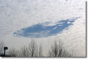
A hole punch cloud is an unusual occurrence when a disk-shaped
hole appears in a cirrostratus, cirrocumulus, or altocumulus cloud.
When part of the cloud forms ice crystals, water droplets in the surrounding area
of the cloud evaporate. The effect of this process produces a large elliptical
gap in the cloud. The hole punch cloud formation is rare, but it is not specific
to any geographic area.
Other names which have been used to describe this phenomena include fallstreak hole,
skypunch, and cloud hole.
Next Topic: Mammatus Clouds
Weather Topic: What are Nimbostratus Clouds?
Home - Education - Cloud Types - Nimbostratus Clouds
 Next Topic: Precipitation
A nimbostratus cloud is similar to a stratus cloud in its formless,
smooth appearance. However, a nimbostratus cloud is darker than a stratus cloud,
because it is thicker.
Unlike a stratus cloud, a nimbostratus cloud typically brings with it the threat
of moderate to heavy precipitation. In some cases, the precipitation may evaporate
before reaching the ground, a phenomenon known as virga.
Next Topic: Precipitation
Current conditions powered by WeatherAPI.com


