Weather Alert in Arkansas
Tornado Watch issued March 7 at 3:19AM CST until March 7 at 8:00AM CST by NWS Little Rock AR
AREAS AFFECTED: Clark, AR; Cleburne, AR; Conway, AR; Dallas, AR; Faulkner, AR; Garland, AR; Grant, AR; Hot Spring, AR; Independence, AR; Johnson, AR; Logan, AR; Lonoke, AR; Montgomery, AR; Newton, AR; Ouachita, AR; Perry, AR; Pike, AR; Polk, AR; Pope, AR; Pulaski, AR; Saline, AR; Scott, AR; Searcy, AR; Stone, AR; Van Buren, AR; White, AR; Yell, AR
DESCRIPTION: THE NATIONAL WEATHER SERVICE HAS ISSUED TORNADO WATCH 22 IN EFFECT UNTIL 8 AM CST THIS MORNING FOR THE FOLLOWING AREAS IN ARKANSAS THIS WATCH INCLUDES 27 COUNTIES IN CENTRAL ARKANSAS CONWAY FAULKNER GARLAND GRANT LONOKE PERRY POPE PULASKI SALINE WHITE YELL IN NORTH CENTRAL ARKANSAS CLEBURNE INDEPENDENCE NEWTON SEARCY STONE VAN BUREN IN SOUTHWEST ARKANSAS CLARK DALLAS HOT SPRING OUACHITA PIKE IN WESTERN ARKANSAS JOHNSON LOGAN MONTGOMERY POLK SCOTT THIS INCLUDES THE CITIES OF ARKADELPHIA, BATESVILLE, BEEBE, BENTON, BOONEVILLE, BRYANT, CABOT, CAMDEN, CLARKSVILLE, CLINTON, CONWAY, DANVILLE, DARDANELLE, FAIRFIELD BAY, FORDYCE, GLENWOOD, HEBER SPRINGS, HOT SPRINGS, JASPER, LESLIE, LITTLE ROCK, LONOKE, MALVERN, MARSHALL, MENA, MORRILTON, MOUNT IDA, MOUNTAIN VIEW, MURFREESBORO, NORMAN, NORTH LITTLE ROCK, OLA, PARIS, PERRYVILLE, RUSSELLVILLE, SEARCY, SHERIDAN, WALDRON, AND WESTERN GROVE.
INSTRUCTION: N/A
Want more detail? Get the Complete 7 Day and Night Detailed Forecast!
Current U.S. National Radar--Current
The Current National Weather Radar is shown below with a UTC Time (subtract 5 hours from UTC to get Eastern Time).

National Weather Forecast--Current
The Current National Weather Forecast and National Weather Map are shown below.

National Weather Forecast for Tomorrow
Tomorrow National Weather Forecast and Tomorrow National Weather Map are show below.

North America Water Vapor (Moisture)
This map shows recent moisture content over North America. Bright and colored areas show high moisture (ie, clouds); brown indicates very little moisture present; black indicates no moisture.

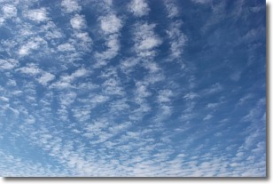
Weather Topic: What are Cirrocumulus Clouds?
Home - Education - Cloud Types - Cirrocumulus Clouds
 Next Topic: Cirrostratus Clouds
Cirrocumulus clouds form at high altitudes (usually around 5 km)
and have distinguishing characteristics displayed in a fine layer of
small cloud patches. These small cloud patches are sometimes referred to as
"cloudlets" in relation to the whole cloud formation.
Cirrocumulus clouds are formed from ice crystals and water droplets. Often, the
water droplets in the cloud freeze into ice crystals and the cloud becomes a
cirrostratus cloud. Because of this common occurrence, cirrocumulus cloud
formations generally pass rapidly.
Next Topic: Cirrostratus Clouds
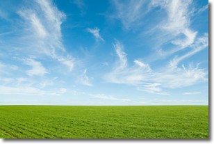
Weather Topic: What are Cirrus Clouds?
Home - Education - Cloud Types - Cirrus Clouds
 Next Topic: Condensation
Cirrus clouds are high-level clouds that occur above 20,000 feet
and are composed mainly of ice crystals.
They are thin and wispy in appearance.
What do they indicate?
They are often the first sign of an approaching storm.
Next Topic: Condensation
Current conditions powered by WeatherAPI.com


