Weather Alert in Indiana
Flood Warning issued March 4 at 12:17PM EST until March 5 at 10:00AM EST by NWS Indianapolis IN
AREAS AFFECTED: Monroe, IN; Morgan, IN; Owen, IN
DESCRIPTION: ...The National Weather Service in Indianapolis IN has issued a Flood Warning for the following rivers in Indiana... White River below Eagle Valley Power Plant. White River near Centerton. White River at Edwardsport. White River at Petersburg. ...Forecast flooding changed from Minor to Moderate severity and increased in duration for the following rivers in Indiana... White River at Elliston. White River at Newberry. .Rainfall amounts between two and four inches over parts of central and southern Indiana have led to rises and some flooding on area rivers. Additional rainfall of one to three inches this evening into Thursday morning, with locally higher amounts possible, will bring widespread minor river flooding with pockets of moderate flooding to much of the East Fork White and lower White River basins. * WHAT...Minor flooding is forecast. * WHERE...White River near Centerton. * WHEN...From this evening to late tomorrow morning. * IMPACTS...At 11.8 feet, Low agricultural fields begin to flood. * ADDITIONAL DETAILS... - At 12:00 PM EST Wednesday the stage was 11.4 feet. - Forecast...The river is expected to rise above flood stage this evening to a crest of 12.1 feet this evening. It will then fall below flood stage late this evening. - Flood stage is 12.0 feet. - http://www.weather.gov/safety/flood
INSTRUCTION: Motorists should not attempt to drive around barricades or drive cars through flooded areas. Additional information is available at www.weather.gov/ind. The next statement should be issued this evening by around 1130 PM EST /1030 PM CST/.
Want more detail? Get the Complete 7 Day and Night Detailed Forecast!
Current U.S. National Radar--Current
The Current National Weather Radar is shown below with a UTC Time (subtract 5 hours from UTC to get Eastern Time).

National Weather Forecast--Current
The Current National Weather Forecast and National Weather Map are shown below.

National Weather Forecast for Tomorrow
Tomorrow National Weather Forecast and Tomorrow National Weather Map are show below.

North America Water Vapor (Moisture)
This map shows recent moisture content over North America. Bright and colored areas show high moisture (ie, clouds); brown indicates very little moisture present; black indicates no moisture.

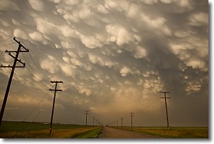
Weather Topic: What are Mammatus Clouds?
Home - Education - Cloud Types - Mammatus Clouds
 Next Topic: Nimbostratus Clouds
A mammatus cloud is a cloud with a unique feature which resembles
a web of pouches hanging along the base of the cloud.
In the United States, mammatus clouds tend to form in the warmer months, commonly
in the Midwest and eastern regions.
While they usually form at the bottom of a cumulonimbis cloud, they can also form
under altostratus, altocumulus, stratocumulus, and cirrus clouds. Mammatus clouds
warn that severe weather is close.
Next Topic: Nimbostratus Clouds
Weather Topic: What is Precipitation?
Home - Education - Precipitation - Precipitation
 Next Topic: Rain
Precipitation can refer to many different forms of water that
may fall from clouds. Precipitation occurs after a cloud has become saturated to
the point where its water particles are more dense than the air below the cloud.
In most cases, precipitation will reach the ground, but it is not uncommon for
precipitation to evaporate before it reaches the earth's surface.
When precipitation evaporates before it contacts the ground it is called Virga.
Graupel, hail, sleet, rain, drizzle, and snow are forms of precipitation, but fog
and mist are not considered precipitation because the water vapor which
constitutes them isn't dense enough to fall to the ground.
Next Topic: Rain
Current conditions powered by WeatherAPI.com


