Weather Alert in Minnesota
High Wind Warning issued February 27 at 10:29AM CST until February 27 at 7:00PM CST by NWS Grand Forks ND
AREAS AFFECTED: West Polk; Kittson; Roseau; West Marshall; East Marshall; Pennington; Red Lake; Towner; Cavalier; Pembina; Ramsey; Eastern Walsh County; Nelson; Grand Forks; Western Walsh County
DESCRIPTION: * WHAT...Northwest winds 35 to 40 mph with gusts up to 60 mph expected. * WHERE...Portions of northwest Minnesota and northeast North Dakota. * WHEN...Until 7 PM CST this evening. * IMPACTS...Very gusty winds will blow around unsecured objects. Travel will become difficult, especially for high profile vehicles. * ADDITIONAL DETAILS...Drifting and blowing snow may lead to icy spots north of US Highway 2, further degrading travel conditions.
INSTRUCTION: Do not travel in high profile vehicle. Use caution if you must drive. Do not use cruise control. Be aware of changing road conditions.
Want more detail? Get the Complete 7 Day and Night Detailed Forecast!
Current U.S. National Radar--Current
The Current National Weather Radar is shown below with a UTC Time (subtract 5 hours from UTC to get Eastern Time).

National Weather Forecast--Current
The Current National Weather Forecast and National Weather Map are shown below.

National Weather Forecast for Tomorrow
Tomorrow National Weather Forecast and Tomorrow National Weather Map are show below.

North America Water Vapor (Moisture)
This map shows recent moisture content over North America. Bright and colored areas show high moisture (ie, clouds); brown indicates very little moisture present; black indicates no moisture.

Weather Topic: What is Graupel?
Home - Education - Precipitation - Graupel
 Next Topic: Hail
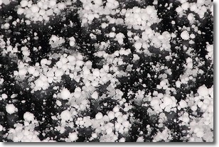
Graupel is a form of precipitation that is created by atmospheric conditions
which cause supercooled water droplets to contact snow crystals and freeze to
their surface.
Sometimes known as soft hail or snow pellets, graupel is delicate and easily
destroyed by touch. Whereas hail usually falls during severe weather, graupel
doesn't require such conditions to form, and can form in mild precipitation
similar to situations which produce snowfall.
Next Topic: Hail
Weather Topic: What are Hole Punch Clouds?
Home - Education - Cloud Types - Hole Punch Clouds
 Next Topic: Mammatus Clouds
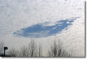
A hole punch cloud is an unusual occurrence when a disk-shaped
hole appears in a cirrostratus, cirrocumulus, or altocumulus cloud.
When part of the cloud forms ice crystals, water droplets in the surrounding area
of the cloud evaporate. The effect of this process produces a large elliptical
gap in the cloud. The hole punch cloud formation is rare, but it is not specific
to any geographic area.
Other names which have been used to describe this phenomena include fallstreak hole,
skypunch, and cloud hole.
Next Topic: Mammatus Clouds
Current conditions powered by WeatherAPI.com


