Weather Alert in Alaska
Winter Weather Advisory issued March 3 at 2:52PM AKST until March 4 at 6:00PM AKST by NWS Juneau AK
AREAS AFFECTED: Municipality of Skagway
DESCRIPTION: ...SNOW FOR THE NORTHERN AND CENTRAL PANHANDLE THROUGH WEDNESDAY... The next surge of snow is expected this evening as the main low moves closer to the panhandle bringing more moisture to the area. This next surge of moisture is expected to bring increasing snowfall rates to the Icy Strait corridor this evening. Along with this second wave of snow, the original band of snow is expected to set up around the Yakutat area bringing more accumulating snow to the area with the heaviest parts to the west of Yakutat. * WHAT...Snow expected. Total snow accumulations of 4 to 6 inches. * WHERE...Municipality of Skagway. * WHEN...From 3 AM to 6 PM AKST Wednesday. * IMPACTS...Travel could be very difficult. The cold wind chills as low as 20 below zero could cause frostbite on exposed skin in as little as 30 minutes.
INSTRUCTION: Slow down and use caution while traveling. People are urged to prepare their property before the onset of winter weather. For the latest road conditions, where available, call 5 1 1 or visit 511.alaska.gov.
Want more detail? Get the Complete 7 Day and Night Detailed Forecast!
Current U.S. National Radar--Current
The Current National Weather Radar is shown below with a UTC Time (subtract 5 hours from UTC to get Eastern Time).

National Weather Forecast--Current
The Current National Weather Forecast and National Weather Map are shown below.

National Weather Forecast for Tomorrow
Tomorrow National Weather Forecast and Tomorrow National Weather Map are show below.

North America Water Vapor (Moisture)
This map shows recent moisture content over North America. Bright and colored areas show high moisture (ie, clouds); brown indicates very little moisture present; black indicates no moisture.

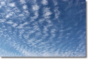
Weather Topic: What are Cirrocumulus Clouds?
Home - Education - Cloud Types - Cirrocumulus Clouds
 Next Topic: Cirrostratus Clouds
Cirrocumulus clouds form at high altitudes (usually around 5 km)
and have distinguishing characteristics displayed in a fine layer of
small cloud patches. These small cloud patches are sometimes referred to as
"cloudlets" in relation to the whole cloud formation.
Cirrocumulus clouds are formed from ice crystals and water droplets. Often, the
water droplets in the cloud freeze into ice crystals and the cloud becomes a
cirrostratus cloud. Because of this common occurrence, cirrocumulus cloud
formations generally pass rapidly.
Next Topic: Cirrostratus Clouds
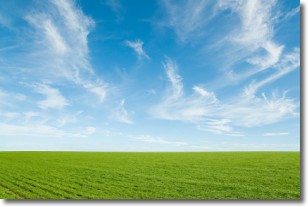
Weather Topic: What are Cirrus Clouds?
Home - Education - Cloud Types - Cirrus Clouds
 Next Topic: Condensation
Cirrus clouds are high-level clouds that occur above 20,000 feet
and are composed mainly of ice crystals.
They are thin and wispy in appearance.
What do they indicate?
They are often the first sign of an approaching storm.
Next Topic: Condensation
Current conditions powered by WeatherAPI.com


