Weather Alert in Maryland
Winter Weather Advisory issued March 2 at 6:39AM EST until March 3 at 10:00AM EST by NWS Baltimore MD/Washington DC
AREAS AFFECTED: Northwest Montgomery; Central and Southeast Montgomery; Northwest Howard; Central and Southeast Howard; Rappahannock; Culpeper; Fairfax; Northern Fauquier; Southern Fauquier; Western Loudoun; Eastern Loudoun; Northwest Prince William; Central and Southeast Prince William/Manassas/Manassas Park
DESCRIPTION: * WHAT...Mixed precipitation expected. Total snow accumulations up to one inch and ice accumulations up to one tenth of an inch. * WHERE...Portions of central Maryland and northern and northwest Virginia. * WHEN...From 10 PM this evening to 10 AM EST Tuesday. * IMPACTS...Plan on slippery road conditions. The hazardous conditions could impact the Tuesday morning commute. * ADDITIONAL DETAILS...Some locations may see up to an inch of snow between late morning and late afternoon today, but roadway impacts should be limited. The primary threat to travel will be overnight from a wintry mix, which could briefly be snow or sleet but primarily fall as freezing rain. Precipitation will change to plain rain by mid morning Tuesday.
INSTRUCTION: Slow down and use caution while traveling. The latest road conditions for the state you are calling from can be obtained by calling 5 1 1.
Want more detail? Get the Complete 7 Day and Night Detailed Forecast!
Current U.S. National Radar--Current
The Current National Weather Radar is shown below with a UTC Time (subtract 5 hours from UTC to get Eastern Time).

National Weather Forecast--Current
The Current National Weather Forecast and National Weather Map are shown below.

National Weather Forecast for Tomorrow
Tomorrow National Weather Forecast and Tomorrow National Weather Map are show below.

North America Water Vapor (Moisture)
This map shows recent moisture content over North America. Bright and colored areas show high moisture (ie, clouds); brown indicates very little moisture present; black indicates no moisture.

Weather Topic: What are Fractus Clouds?
Home - Education - Cloud Types - Fractus Clouds
 Next Topic: Freezing Rain
A fractus cloud (scud) is a fragmented, tattered cloud which has
likely been sheared off of another cloud. They are accessory clouds, meaning they
develop from parent clouds, and are named in a way which describes the original
cloud which contained them.
Fractus clouds which have originated from cumulus clouds are referred to as
cumulus fractus, while fractus clouds which have originated from stratus clouds
are referred to as stratus fractus. Under certain conditions a fractus cloud might
merge with another cloud, or develop into a cumulus cloud, but usually a
fractus cloud seen by itself will dissipate rapidly.
They are often observed on the leading and trailing edges of storm clouds,
and are a display of wind activity.
Next Topic: Freezing Rain
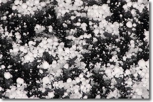
Weather Topic: What is Graupel?
Home - Education - Precipitation - Graupel
 Next Topic: Hail
Graupel is a form of precipitation that is created by atmospheric conditions
which cause supercooled water droplets to contact snow crystals and freeze to
their surface.
Sometimes known as soft hail or snow pellets, graupel is delicate and easily
destroyed by touch. Whereas hail usually falls during severe weather, graupel
doesn't require such conditions to form, and can form in mild precipitation
similar to situations which produce snowfall.
Next Topic: Hail
Current conditions powered by WeatherAPI.com


