Weather Alert in Michigan
Winter Storm Warning issued February 24 at 2:19PM EST until February 24 at 7:00PM EST by NWS Marquette MI
AREAS AFFECTED: Alger; Luce; Northern Schoolcraft
DESCRIPTION: * WHAT...For the Winter Storm Warning, heavy snow. Additional snow accumulations between 3 and 7 inches. Winds gusting as high as 35 mph. For the Winter Weather Advisory, lake effect snow expected. Total snow accumulations between 3 and 6 inches. * WHERE...Alger, Luce, and Northern Schoolcraft Counties. * WHEN...For the Winter Storm Warning, until 7 PM EST this evening. For the Winter Weather Advisory, from 10 PM this evening to 7 PM EST Wednesday. * IMPACTS...Plan on slippery road conditions. Areas of blowing snow will significantly reduce visibility. The hazardous conditions will impact the Tuesday evening and Wednesday morning commutes. Visibilities may drop below 1/4 mile due to falling and blowing snow. * ADDITIONAL DETAILS...The highest snowfall amounts this afternoon and early evening are expected to be east of Munising with snowfall rates of one inch per hour expected. Lake effect snow will develop late this evening and continue into Wednesday
INSTRUCTION: Slow down and use caution while traveling. If you must travel, keep an extra flashlight, food, and water in your vehicle in case of an emergency.
Want more detail? Get the Complete 7 Day and Night Detailed Forecast!
Current U.S. National Radar--Current
The Current National Weather Radar is shown below with a UTC Time (subtract 5 hours from UTC to get Eastern Time).

National Weather Forecast--Current
The Current National Weather Forecast and National Weather Map are shown below.

National Weather Forecast for Tomorrow
Tomorrow National Weather Forecast and Tomorrow National Weather Map are show below.

North America Water Vapor (Moisture)
This map shows recent moisture content over North America. Bright and colored areas show high moisture (ie, clouds); brown indicates very little moisture present; black indicates no moisture.

Weather Topic: What is Hail?
Home - Education - Precipitation - Hail
 Next Topic: Hole Punch Clouds
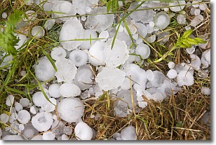
Hail is a form of precipitation which is recognized by large solid balls or
clumps of ice. Hail is created by thunderstorm clouds with strong updrafts of wind.
As the hailstones remain in the updraft, ice is deposited onto them until their
weight becomes heavy enough for them to fall to the earth's surface.
Hail storms can cause significant damage to crops, aircrafts, and man-made structures,
despite the fact that the duration is usually less than ten minutes.
Next Topic: Hole Punch Clouds
Weather Topic: What are Mammatus Clouds?
Home - Education - Cloud Types - Mammatus Clouds
 Next Topic: Nimbostratus Clouds
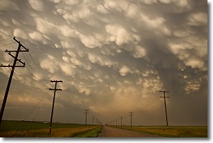
A mammatus cloud is a cloud with a unique feature which resembles
a web of pouches hanging along the base of the cloud.
In the United States, mammatus clouds tend to form in the warmer months, commonly
in the Midwest and eastern regions.
While they usually form at the bottom of a cumulonimbis cloud, they can also form
under altostratus, altocumulus, stratocumulus, and cirrus clouds. Mammatus clouds
warn that severe weather is close.
Next Topic: Nimbostratus Clouds
Current conditions powered by WeatherAPI.com


