Weather Alert in California
Flood Warning issued February 24 at 7:59AM PST until February 25 at 4:00AM PST by NWS Eureka CA
AREAS AFFECTED: Mendocino, CA
DESCRIPTION: ...The National Weather Service in Eureka has issued a Flood Warning for the following rivers in California... Russian River near Hopland affecting Mendocino County. For the Russian River...including Hopland...Minor flooding is forecast. * WHAT...Minor flooding is forecast. * WHERE...Russian River near Hopland. * WHEN...From this morning to late tonight. * IMPACTS...At 15.0 feet, Flooding of Highway 175 is expected at the approaches to the Russian River bridge. Expect flooding of cropland on the right bank of river. At 17.0 feet, Significant flooding of Highway 175 at the approaches to the Russian River bridge. Minor flooding of Highway 222 near Ukiah, and in crop land along the left and right banks of the Russian River near Hopland. * ADDITIONAL DETAILS... - At 7:45 AM PST Tuesday the stage was 5.7 feet. - Bankfull stage is 21.0 feet. - Forecast...The river is expected to rise above flood stage late this morning to a crest of 16.6 feet this evening. It will then fall below flood stage late this evening. - Flood stage is 15.0 feet. - Flood History...This crest compares to a previous crest of 16.7 feet on 10/24/2021. - http://www.weather.gov/safety/flood
INSTRUCTION: Turn around, don't drown when encountering flooded roads. Most flood deaths occur in vehicles. Motorists should not attempt to drive around barricades or drive cars through flooded areas. Stay tuned to further developments by listening to your local radio, television, or NOAA Weather Radio for further information. Flooding is occurring or is imminent. Most flood related deaths occur in automobiles. Do not attempt to cross water covered bridges, dips, or low water crossings. Never try to cross a flowing stream, even a small one, on foot. To escape rising water find another route over higher ground. This warning will be in effect until the river falls below its flood stage. Please report observed flooding to local emergency services or law enforcement and request they pass this information to the National Weather Service when you can do so safely. Additional information is available at weather.gov/eka. The next statement will be issued this evening at 800 PM PST.
Want more detail? Get the Complete 7 Day and Night Detailed Forecast!
Current U.S. National Radar--Current
The Current National Weather Radar is shown below with a UTC Time (subtract 5 hours from UTC to get Eastern Time).

National Weather Forecast--Current
The Current National Weather Forecast and National Weather Map are shown below.

National Weather Forecast for Tomorrow
Tomorrow National Weather Forecast and Tomorrow National Weather Map are show below.

North America Water Vapor (Moisture)
This map shows recent moisture content over North America. Bright and colored areas show high moisture (ie, clouds); brown indicates very little moisture present; black indicates no moisture.

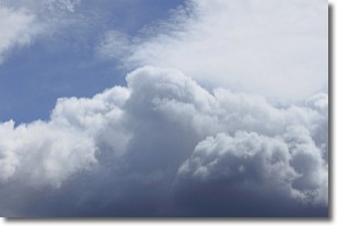
Weather Topic: What are Nimbostratus Clouds?
Home - Education - Cloud Types - Nimbostratus Clouds
 Next Topic: Precipitation
A nimbostratus cloud is similar to a stratus cloud in its formless,
smooth appearance. However, a nimbostratus cloud is darker than a stratus cloud,
because it is thicker.
Unlike a stratus cloud, a nimbostratus cloud typically brings with it the threat
of moderate to heavy precipitation. In some cases, the precipitation may evaporate
before reaching the ground, a phenomenon known as virga.
Next Topic: Precipitation
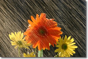
Weather Topic: What is Rain?
Home - Education - Precipitation - Rain
 Next Topic: Shelf Clouds
Precipitation in the form of water droplets is called rain.
Rain generally has a tendency to fall with less intensity over a greater period
of time, and when rainfall is more severe it is usually less sustained.
Rain is the most common form of precipitation and happens with greater frequency
depending on the season and regional influences. Cities have been shown to have
an observable effect on rainfall, due to an effect called the urban heat island.
Compared to upwind, monthly rainfall between twenty and forty miles downwind of
cities is 30% greater.
Next Topic: Shelf Clouds
Current conditions powered by WeatherAPI.com


