Weather Alert in Florida
Freeze Watch Rip Current Statement
Fire Weather Watch issued February 21 at 1:10PM EST until February 23 at 7:00PM EST by NWS Jacksonville FL
AREAS AFFECTED: Suwannee; Baker; Inland Nassau; Union; Bradford; Gilchrist; Inland Flagler; Eastern Hamilton; Coastal Nassau; Coastal Duval; Eastern Clay; Eastern Alachua; Eastern Putnam; Coastal Flagler; Eastern Marion; Western Hamilton; Trout River; Western Clay; Northeast Coastal St. Johns; Western Alachua; Western Putnam; Central Marion; Northern Columbia; South Central Duval; Southeast Coastal St. Johns; Western Marion; Southeastern Columbia; Western Duval; Northern Inland St. Johns; Southwestern Columbia; Southern Inland St. Johns; Western St. Johns; Echols; Clinch; Northeastern Charlton; Southern Ware; Western Charlton
DESCRIPTION: ...FIRE WEATHER WATCH IN EFFECT FROM MONDAY AFTERNOON THROUGH MONDAY EVENING FOR LOW HUMIDITY AND STRONG NORTHWESTERLY WINDS FOR SOUTHEAST GEORGIA AND NORTHEAST FLORIDA... The National Weather Service in Jacksonville has issued a Red Flag Warning for critically low humidity and strong northwesterly winds, which is in effect from 1 PM to 9 PM EST Sunday. A Fire Weather Watch has also been issued. This Fire Weather Watch for an additional period of critical fire weather conditions and in effect from Monday afternoon through Monday evening. * AFFECTED AREA...In Florida, Suwannee, Baker, Inland Nassau, Union, Bradford, Gilchrist, Inland Flagler, Eastern Hamilton, Coastal Nassau, Coastal Duval, Eastern Clay, Eastern Alachua, Eastern Putnam, Coastal Flagler, Eastern Marion, Western Hamilton, Trout River, Western Clay, Northeast Coastal St. Johns, Western Alachua, Western Putnam, Central Marion, Northern Columbia, South Central Duval, Southeast Coastal St. Johns, Western Marion, Southeastern Columbia, Western Duval, Northern Inland St. Johns, Southwestern Columbia, Southern Inland St. Johns and Western St. Johns. In Georgia, Echols, Clinch, Northeastern Charlton, Southern Ware and Western Charlton. * TIMING...1 PM to 9 PM. * WINDS...Northwest 15 to 25 mph with gusts up to 35 mph. * RELATIVE HUMIDITY...As low as 24 percent. * TEMPERATURES...Up to 69. * IMPACTS...Ongoing wildfires will become difficult to contain and newly ignited fires may exhibit erratic fire behavior. Rapid rates of wildfire spread is expected.
INSTRUCTION: A Red Flag Warning means that critical fire weather conditions are either occurring now, or will shortly. A combination of strong winds, low relative humidity, and warm temperatures can contribute to extreme fire behavior. A Fire Weather Watch means that critical fire weather conditions are forecast to occur. Listen for later forecasts and possible Red Flag Warnings.
Want more detail? Get the Complete 7 Day and Night Detailed Forecast!
Current U.S. National Radar--Current
The Current National Weather Radar is shown below with a UTC Time (subtract 5 hours from UTC to get Eastern Time).

National Weather Forecast--Current
The Current National Weather Forecast and National Weather Map are shown below.

National Weather Forecast for Tomorrow
Tomorrow National Weather Forecast and Tomorrow National Weather Map are show below.

North America Water Vapor (Moisture)
This map shows recent moisture content over North America. Bright and colored areas show high moisture (ie, clouds); brown indicates very little moisture present; black indicates no moisture.

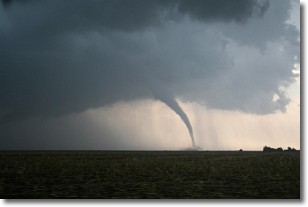
Weather Topic: What are Wall Clouds?
Home - Education - Cloud Types - Wall Clouds
 Next Topic: Altocumulus Clouds
A wall cloud forms underneath the base of a cumulonimbus cloud,
and can be a hotbed for deadly tornadoes.
Wall clouds are formed by air flowing into the cumulonimbus clouds, which can
result in the wall cloud descending from the base of the cumulonimbus cloud, or
rising fractus clouds which join to the base of the storm cloud as the wall cloud
takes shape.
Wall clouds can be very large, and in the Northern Hemisphere they generally
form at the southern edge of cumulonimbus clouds.
Next Topic: Altocumulus Clouds
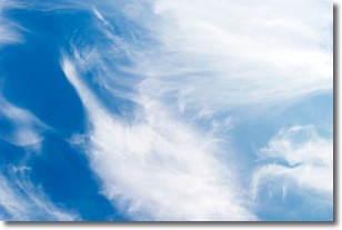
Weather Topic: What are Altostratus Clouds?
Home - Education - Cloud Types - Altostratus Clouds
 Next Topic: Cirrocumulus Clouds
Altostratus clouds form at mid to high-level altitudes
(between 2 and 7 km) and are created by a warm, stable air mass which causes
water vapor
to condense as it rise through the atmosphere. Usually altostratus clouds are
featureless sheets characterized by a uniform color.
In some cases, wind punching through the cloud formation may give it a waved
appearance, called altostratus undulatus. Altostratus clouds
are commonly seen with other cloud formations accompanying them.
Next Topic: Cirrocumulus Clouds
Current conditions powered by WeatherAPI.com


