Weather Alert in Georgia
Red Flag Warning issued February 23 at 11:42AM EST until February 23 at 7:00PM EST by NWS Peachtree City GA
AREAS AFFECTED: Heard; Troup; Meriwether; Upson; Harris; Talbot; Taylor; Crawford; Muscogee; Chattahoochee; Marion; Schley; Macon; Peach; Houston; Stewart; Webster; Sumter; Dooly; Crisp; Pulaski; Wilcox; Dodge; Telfair; Wheeler; Montgomery; Toombs
DESCRIPTION: The National Weather Service in Peachtree City has issued a Red Flag Warning for gusty winds, low relative humidity, and dry fuels, which is in effect until 7 PM EST this evening. * Affected Area... South and east central Georgia. * Timing... This afternoon through early evening. * Winds... Northwest at 10 to 15 mph with gusts up to 25 mph. * Relative Humidity... Falling below 25 percent by early afternoon. * Temperatures... 40s. * Impacts... With elevated winds and low relative humidities, critical fire weather conditions are possible. Outdoor burning is strongly discouraged.
INSTRUCTION: This warning includes the Oconee National Forest. A Red Flag Warning means that critical fire weather conditions are either occurring...or will occur within 24 hours. Please refer to the local burn permitting authorities on whether you may burn outdoors. If you do burn outside...use extreme caution. Please advise the appropriate officials or fire crews in the field of the Red Flag Warning.
Want more detail? Get the Complete 7 Day and Night Detailed Forecast!
Current U.S. National Radar--Current
The Current National Weather Radar is shown below with a UTC Time (subtract 5 hours from UTC to get Eastern Time).

National Weather Forecast--Current
The Current National Weather Forecast and National Weather Map are shown below.

National Weather Forecast for Tomorrow
Tomorrow National Weather Forecast and Tomorrow National Weather Map are show below.

North America Water Vapor (Moisture)
This map shows recent moisture content over North America. Bright and colored areas show high moisture (ie, clouds); brown indicates very little moisture present; black indicates no moisture.

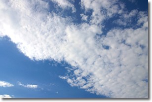
Weather Topic: What are Stratus Clouds?
Home - Education - Cloud Types - Stratus Clouds
 Next Topic: Wall Clouds
Stratus clouds are similar to altostratus clouds, but form at a
lower altitude and are identified by their fog-like appearance, lacking the
distinguishing features of most clouds.
Stratus clouds are wider than most clouds, and their base has a smooth, uniform
look which is lighter in color than a nimbostratus cloud.
The presence of a stratus cloud indicates the possibility of minor precipitation,
such as drizzle, but heavier precipitation does not typically arrive in the form
of a stratus cloud.
Next Topic: Wall Clouds
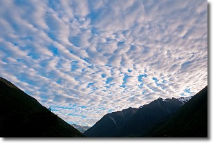
Weather Topic: What are Altocumulus Clouds?
Home - Education - Cloud Types - Altocumulus Clouds
 Next Topic: Altostratus Clouds
Similar to cirrocumulus clouds, altocumulus clouds are
characterized by cloud patches. They are distinguished by larger cloudlets
than cirrocumulus clouds but are still smaller than stratocumulus clouds.
Altocumulus clouds most commonly form in middle altitudes (between 2 and 5 km)
and may resemble, at times, the shape of a flying saucer.
These uncommon formations, called altocumulus lenticularis, are created by uplift
in the atmosphere and are most often seen in close proximity to mountains.
Next Topic: Altostratus Clouds
Current conditions powered by WeatherAPI.com


