Weather Alert in Florida
Freeze Watch Red Flag Warning
Cold Weather Advisory issued February 22 at 12:02PM EST until February 23 at 9:00AM EST by NWS Jacksonville FL
AREAS AFFECTED: Coastal Nassau; Coastal Duval; Trout River; South Central Duval; Western Duval
DESCRIPTION: * WHAT...For the Wind Advisory, northwest winds around 20 mph with gusts up to 30 mph. For the Cold Weather Advisory, very cold wind chills as low as 23 expected. For the Freeze Watch, sub-freezing temperatures as low as 28 possible. * WHERE...Coastal Duval, Coastal Nassau, South Central Duval, Trout River, and Western Duval Counties. * WHEN...For the Wind Advisory, until 6 PM EST this evening. For the Cold Weather Advisory, from 4 AM to 9 AM EST Monday. For the Freeze Watch, from late Monday night through Tuesday morning. * IMPACTS...Gusty winds will blow around unsecured objects. Tree limbs could be blown down and a few power outages may result. The cold wind chills as low as 25 degrees could result in hypothermia or frostbite if precautions are not taken. Wind chill values can lead to hypothermia with prolonged exposure. Appropriate action should be taken to ensure tender vegetation and outdoor pets have adequate protection from the cold temperatures. Young children, the elderly and the homeless are especially vulnerable to the cold. Take measures to protect them.
INSTRUCTION: Winds this strong can make driving difficult, especially for high profile vehicles. Use extra caution. Secure outdoor objects. Use caution while traveling outside. Wear appropriate clothing, a hat, and gloves. Keep pets indoors as much as possible. Take steps now to protect tender plants from the cold. To prevent water pipes from freezing; wrap or drain or allow them to drip slowly.
Want more detail? Get the Complete 7 Day and Night Detailed Forecast!
Current U.S. National Radar--Current
The Current National Weather Radar is shown below with a UTC Time (subtract 5 hours from UTC to get Eastern Time).

National Weather Forecast--Current
The Current National Weather Forecast and National Weather Map are shown below.

National Weather Forecast for Tomorrow
Tomorrow National Weather Forecast and Tomorrow National Weather Map are show below.

North America Water Vapor (Moisture)
This map shows recent moisture content over North America. Bright and colored areas show high moisture (ie, clouds); brown indicates very little moisture present; black indicates no moisture.

Weather Topic: What are Contrails?
Home - Education - Cloud Types - Contrails
 Next Topic: Cumulonimbus Clouds
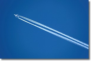
A contrail is an artificial cloud, created by the passing of an
aircraft.
Contrails form because water vapor in the exhaust of aircraft engines is suspended
in the air under certain temperatures and humidity conditions. These contrails
are called exhaust contrails.
Another type of contrail can form due to a temporary reduction in air pressure
moving over the plane's surface, causing condensation.
These are called aerodynamic contrails.
When you can see your breath on a cold day, it is also because of condensation.
The reason contrails last longer than the condensation from your breath is
because the water in contrails freezes into ice particles.
Next Topic: Cumulonimbus Clouds
Weather Topic: What are Cumulus Clouds?
Home - Education - Cloud Types - Cumulus Clouds
 Next Topic: Drizzle
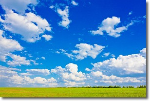
Cumulus clouds are fluffy and textured with rounded tops, and
may have flat bottoms. The border of a cumulus cloud
is clearly defined, and can have the appearance of cotton or cauliflower.
Cumulus clouds form at low altitudes (rarely above 2 km) but can grow very tall,
becoming cumulus congestus and possibly the even taller cumulonimbus clouds.
When cumulus clouds become taller, they have a greater chance of producing precipitation.
Next Topic: Drizzle
Current conditions powered by WeatherAPI.com


