Weather Alert in Florida
Fire Weather Watch issued February 21 at 1:12PM EST until February 23 at 7:00PM EST by NWS Miami FL
AREAS AFFECTED: Metro Palm Beach County; Coastal Collier County; Inland Broward County; Metro Broward County; Inland Miami-Dade County; Metropolitan Miami Dade; Mainland Monroe; Glades County Lake Region; Hendry County Lakes Region; Palm Beach County Lake Region; Coastal Palm Beach County; Big Cypress; Coastal Broward County; Coastal Miami Dade County; Far South Miami-Dade County; Glades County; Hendry County; Inland Palm Beach County; Northern Collier; Southwest Collier
DESCRIPTION: The National Weather Service in Miami has issued a Fire Weather Watch, which is in effect from Monday morning through Monday evening. * AFFECTED AREA...Fire Weather Zone 068 Metro Palm Beach County, Fire Weather Zone 069 Coastal Collier County, Fire Weather Zone 071 Inland Broward County, Fire Weather Zone 072 Metro Broward County, Fire Weather Zone 073 Inland Miami-Dade County, Fire Weather Zone 074 Metropolitan Miami Dade, Fire Weather Zone 075 Mainland Monroe, Fire Weather Zone 163 Glades County Lake Region, Fire Weather Zone 166 Hendry County Lakes Region, Fire Weather Zone 167 Palm Beach County Lake Region, Fire Weather Zone 168 Coastal Palm Beach County, Fire Weather Zone 170 Big Cypress, Fire Weather Zone 172 Coastal Broward County, Fire Weather Zone 173 Coastal Miami Dade County, Fire Weather Zone 174 Far South Miami-Dade County, Fire Weather Zone 263 Glades County, Fire Weather Zone 266 Hendry County, Fire Weather Zone 267 Inland Palm Beach County, Fire Weather Zone 270 Northern Collier and Fire Weather Zone 370 Southwest Collier. * TIMING...From Monday morning through Monday evening. * WINDS...Northwest 10 to 15 mph with gusts up to 30 mph. * RELATIVE HUMIDITY...As low as 23 percent. * TEMPERATURES...Up to 65. * LIGHTNING... * IMPACTS...
INSTRUCTION: A Fire Weather Watch means that critical fire weather conditions are forecast to occur. Listen for later forecasts and possible Red Flag Warnings.
Want more detail? Get the Complete 7 Day and Night Detailed Forecast!
Current U.S. National Radar--Current
The Current National Weather Radar is shown below with a UTC Time (subtract 5 hours from UTC to get Eastern Time).

National Weather Forecast--Current
The Current National Weather Forecast and National Weather Map are shown below.

National Weather Forecast for Tomorrow
Tomorrow National Weather Forecast and Tomorrow National Weather Map are show below.

North America Water Vapor (Moisture)
This map shows recent moisture content over North America. Bright and colored areas show high moisture (ie, clouds); brown indicates very little moisture present; black indicates no moisture.

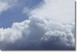
Weather Topic: What are Nimbostratus Clouds?
Home - Education - Cloud Types - Nimbostratus Clouds
 Next Topic: Precipitation
A nimbostratus cloud is similar to a stratus cloud in its formless,
smooth appearance. However, a nimbostratus cloud is darker than a stratus cloud,
because it is thicker.
Unlike a stratus cloud, a nimbostratus cloud typically brings with it the threat
of moderate to heavy precipitation. In some cases, the precipitation may evaporate
before reaching the ground, a phenomenon known as virga.
Next Topic: Precipitation
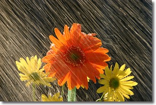
Weather Topic: What is Rain?
Home - Education - Precipitation - Rain
 Next Topic: Shelf Clouds
Precipitation in the form of water droplets is called rain.
Rain generally has a tendency to fall with less intensity over a greater period
of time, and when rainfall is more severe it is usually less sustained.
Rain is the most common form of precipitation and happens with greater frequency
depending on the season and regional influences. Cities have been shown to have
an observable effect on rainfall, due to an effect called the urban heat island.
Compared to upwind, monthly rainfall between twenty and forty miles downwind of
cities is 30% greater.
Next Topic: Shelf Clouds
Current conditions powered by WeatherAPI.com


