Weather Alert in Ohio
Flood Warning issued March 4 at 5:54AM EST until March 4 at 1:30PM EST by NWS Charleston WV
AREAS AFFECTED: Athens, OH; Gallia, OH; Jackson, OH; Meigs, OH; Vinton, OH; Washington, OH; Jackson, WV; Mason, WV; Pleasants, WV; Wirt, WV; Wood, WV
DESCRIPTION: * WHAT...Flooding caused by excessive rainfall continues. * WHERE...Portions of southeast Ohio, including the following counties, Athens, Gallia, Jackson, Meigs, Vinton and Washington and West Virginia, including the following counties, Jackson, Mason, Pleasants, Wirt and Wood. * WHEN...Until 130 PM EST Wednesday. * IMPACTS...Flooding of rivers, creeks, streams, and other low-lying and flood-prone locations is imminent or occurring. * ADDITIONAL DETAILS... - At 541 AM EST, Earlier heavy rain has lessened this morning, but additional rounds of moderate to heavy rain are likely later this morning. Between 1 and 2 inches of rain have fallen and flooding is already occurring within the warned area. Portions of Stillwell Road are flooded. Additionally, the Shade River near Chester is in action stage and approaching minor flood stage. At 14 feet, low lying areas adjacent to the river flood. Little Tygart Creek at Mineral Wells is also in action stage and approaching minor flood stage. At 10 to 11 feet, Irene Lane and low spots on Woodbridge Golf Course will begin to flood. Upper portions of Raccoon Creek is likely flooding low spots adjacenent the creek. - Additional rainfall amounts up to 0.5 inches are possible in the warned area this morning. Additional rain is likely late morning into the afternoon. - Some locations that will experience flooding include... Parkersburg, Athens, Belpre, Jackson, Wellston, Pomeroy, Mcarthur, Albany, Elizabeth, Racine, Coolville, Rutland, Forked Run State Park, Lake Hope State Park, Vienna, New Haven, Mason, Tuppers Plains, Washington and Lubeck. - http://www.weather.gov/safety/flood
INSTRUCTION: Turn around, don't drown when encountering flooded roads. Most flood deaths occur in vehicles. Report flooding to the National Weather Service by calling toll free, 800 401 9535, when you can do so safely.
Want more detail? Get the Complete 7 Day and Night Detailed Forecast!
Current U.S. National Radar--Current
The Current National Weather Radar is shown below with a UTC Time (subtract 5 hours from UTC to get Eastern Time).

National Weather Forecast--Current
The Current National Weather Forecast and National Weather Map are shown below.

National Weather Forecast for Tomorrow
Tomorrow National Weather Forecast and Tomorrow National Weather Map are show below.

North America Water Vapor (Moisture)
This map shows recent moisture content over North America. Bright and colored areas show high moisture (ie, clouds); brown indicates very little moisture present; black indicates no moisture.

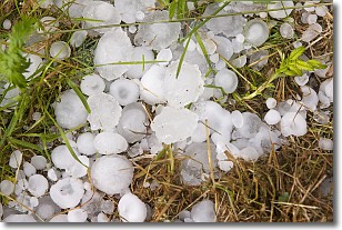
Weather Topic: What is Hail?
Home - Education - Precipitation - Hail
 Next Topic: Hole Punch Clouds
Hail is a form of precipitation which is recognized by large solid balls or
clumps of ice. Hail is created by thunderstorm clouds with strong updrafts of wind.
As the hailstones remain in the updraft, ice is deposited onto them until their
weight becomes heavy enough for them to fall to the earth's surface.
Hail storms can cause significant damage to crops, aircrafts, and man-made structures,
despite the fact that the duration is usually less than ten minutes.
Next Topic: Hole Punch Clouds
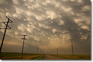
Weather Topic: What are Mammatus Clouds?
Home - Education - Cloud Types - Mammatus Clouds
 Next Topic: Nimbostratus Clouds
A mammatus cloud is a cloud with a unique feature which resembles
a web of pouches hanging along the base of the cloud.
In the United States, mammatus clouds tend to form in the warmer months, commonly
in the Midwest and eastern regions.
While they usually form at the bottom of a cumulonimbis cloud, they can also form
under altostratus, altocumulus, stratocumulus, and cirrus clouds. Mammatus clouds
warn that severe weather is close.
Next Topic: Nimbostratus Clouds
Current conditions powered by WeatherAPI.com


