Weather Alert in California
Winter Weather Advisory issued February 21 at 12:49PM PST until February 22 at 4:00PM PST by NWS Medford OR
AREAS AFFECTED: Western Siskiyou County; South Central Siskiyou County; North Central and Southeast Siskiyou County
DESCRIPTION: * WHAT...Snow expected above 4500 feet in Siskiyou County. Total snow accumulations 3 to 6 inches. Winds gusting as high as 60 mph over high and exposed terrain. * WHERE...Above 4500 feet in Siskiyou County Including the locations of...Bray, Tennant. This also includes the following passes or notable locations... Dead Horse Summit on State Highway 89 at 4489 ft. Etna Summit on Sawyers Bar Rd at 5950 ft. Mt. Shasta ski park highway around 5400 ft. Grass Lake at Mt. Hebron at 5291 ft. Bunny Flat on Everitt Memorial highway at 6900 ft. * WHEN...From 10 PM this evening to 4 PM PST Sunday. * IMPACTS...Travel may be very difficult to impossible. Strong winds could cause tree damage and low visibility. * ADDITIONAL DETAILS... Visit weather.gov/mfr/winter for additional snow probabilities
INSTRUCTION: Slow down and use caution while traveling. Call 511 or visit quickmap.dot.ca.gov for road information.
Want more detail? Get the Complete 7 Day and Night Detailed Forecast!
Current U.S. National Radar--Current
The Current National Weather Radar is shown below with a UTC Time (subtract 5 hours from UTC to get Eastern Time).

National Weather Forecast--Current
The Current National Weather Forecast and National Weather Map are shown below.

National Weather Forecast for Tomorrow
Tomorrow National Weather Forecast and Tomorrow National Weather Map are show below.

North America Water Vapor (Moisture)
This map shows recent moisture content over North America. Bright and colored areas show high moisture (ie, clouds); brown indicates very little moisture present; black indicates no moisture.

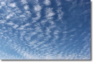
Weather Topic: What are Cirrocumulus Clouds?
Home - Education - Cloud Types - Cirrocumulus Clouds
 Next Topic: Cirrostratus Clouds
Cirrocumulus clouds form at high altitudes (usually around 5 km)
and have distinguishing characteristics displayed in a fine layer of
small cloud patches. These small cloud patches are sometimes referred to as
"cloudlets" in relation to the whole cloud formation.
Cirrocumulus clouds are formed from ice crystals and water droplets. Often, the
water droplets in the cloud freeze into ice crystals and the cloud becomes a
cirrostratus cloud. Because of this common occurrence, cirrocumulus cloud
formations generally pass rapidly.
Next Topic: Cirrostratus Clouds
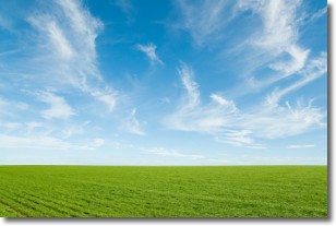
Weather Topic: What are Cirrus Clouds?
Home - Education - Cloud Types - Cirrus Clouds
 Next Topic: Condensation
Cirrus clouds are high-level clouds that occur above 20,000 feet
and are composed mainly of ice crystals.
They are thin and wispy in appearance.
What do they indicate?
They are often the first sign of an approaching storm.
Next Topic: Condensation
Current conditions powered by WeatherAPI.com


