Weather Alert in West Virginia
Winter Storm Warning issued March 2 at 12:49AM EST until March 3 at 10:00AM EST by NWS Charleston WV
AREAS AFFECTED: Northwest Pocahontas; Southeast Randolph
DESCRIPTION: * WHAT...Heavy mixed precipitation expected. Total snow accumulations between 1 and 3 inches and ice accumulations up to three tenths of an inch. Locally higher amounts of ice accumulations could be possible. * WHERE...Northwest Pocahontas and Southeast Randolph Counties. * WHEN...From 7 AM this morning to 10 AM EST Tuesday. * IMPACTS...Power outages and tree damage are likely due to the ice. Travel could be nearly impossible this evening into Tuesday morning. The hazardous conditions could impact the morning and evening commutes as well as the Tuesday morning commute. * ADDITIONAL DETAILS...This event will start as all snow with a bulk of the snow accumulations falling this morning into the early afternoon. Freezing rain is then expected to start mixing in by the afternoon and will continue into the evening. This mix is expected to become mostly freezing rain tonight into Tuesday morning. This time period is where a bulk of the ice accretions will occur resulting in the impacts listed.
INSTRUCTION: If you must travel, keep an extra flashlight, food, and water in your vehicle in case of an emergency. The latest road conditions for the state you are calling from can be obtained by calling 5 1 1 or by accessing the online traffic and roadway portal for your state. Additional information can be found at https://www.weather.gov/rlx as well as on our X and Facebook pages.
Want more detail? Get the Complete 7 Day and Night Detailed Forecast!
Current U.S. National Radar--Current
The Current National Weather Radar is shown below with a UTC Time (subtract 5 hours from UTC to get Eastern Time).

National Weather Forecast--Current
The Current National Weather Forecast and National Weather Map are shown below.

National Weather Forecast for Tomorrow
Tomorrow National Weather Forecast and Tomorrow National Weather Map are show below.

North America Water Vapor (Moisture)
This map shows recent moisture content over North America. Bright and colored areas show high moisture (ie, clouds); brown indicates very little moisture present; black indicates no moisture.

Weather Topic: What is Sleet?
Home - Education - Precipitation - Sleet
 Next Topic: Snow
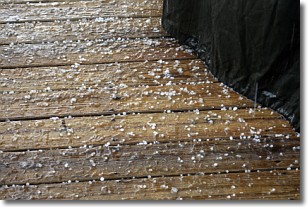
Sleet is a form of precipitation in which small ice pellets are the primary
components. These ice pellets are smaller and more translucent than hailstones,
and harder than graupel. Sleet is caused by specific atmospheric conditions and
therefore typically doesn't last for extended periods of time.
The condition which leads to sleet formation requires a warmer body of air to be
wedged in between two sub-freezing bodies of air. When snow falls through a warmer
layer of air it melts, and as it falls through the next sub-freezing body of air
it freezes again, forming ice pellets known as sleet. In some cases, water
droplets don't have time to freeze before reaching the surface and the result is
freezing rain.
Next Topic: Snow
Weather Topic: What are Stratocumulus Clouds?
Home - Education - Cloud Types - Stratocumulus Clouds
 Next Topic: Stratus Clouds
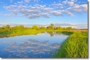
Stratocumulus clouds are similar to altocumulus clouds in their
fluffy appearance, but have a slightly darker shade due to their additional mass.
A good way to distinguish the two cloud types is to hold your hand out and measure
the size of an individual cloud; if it is the size of your thumb it is generally
an altocumulus cloud, if it is the size of your hand it is generally a
stratocumulus cloud.
It is uncommon for stratocumulus clouds to produce precipitation, but if they do
it is usually a light rain or snow.
Next Topic: Stratus Clouds
Current conditions powered by WeatherAPI.com


