Weather Alert in Florida
Rip Current Statement Special Weather Statement
Freeze Watch issued February 22 at 12:42AM EST until February 24 at 9:00AM EST by NWS Jacksonville FL
AREAS AFFECTED: Baker; Inland Nassau; Eastern Hamilton; Western Hamilton; Northern Columbia; Coffee; Jeff Davis; Bacon; Appling; Wayne; Atkinson; Pierce; Brantley; Inland Glynn; Coastal Glynn; Echols; Clinch; Inland Camden; Coastal Camden; Northern Ware; Northeastern Charlton; Southern Ware; Western Charlton
DESCRIPTION: * WHAT...For the Freeze Warning, sub-freezing temperatures as low as 30 expected. For the Freeze Watch, sub-freezing temperatures as low as 25 possible. * WHERE...Portions of northeast and northern Florida and southeast Georgia. * WHEN...For the Freeze Warning, from midnight tonight to 9 AM EST Monday. For the Freeze Watch, from late Monday night through Tuesday morning. * IMPACTS...Appropriate action should be taken to ensure tender vegetation and outdoor pets have adequate protection from the cold temperatures. Young children, the elderly and the homeless are especially vulnerable to the cold. Take measures to protect them.
INSTRUCTION: Take steps now to protect tender plants from the cold. To prevent water pipes from freezing; wrap or drain or allow them to drip slowly.
Want more detail? Get the Complete 7 Day and Night Detailed Forecast!
Current U.S. National Radar--Current
The Current National Weather Radar is shown below with a UTC Time (subtract 5 hours from UTC to get Eastern Time).

National Weather Forecast--Current
The Current National Weather Forecast and National Weather Map are shown below.

National Weather Forecast for Tomorrow
Tomorrow National Weather Forecast and Tomorrow National Weather Map are show below.

North America Water Vapor (Moisture)
This map shows recent moisture content over North America. Bright and colored areas show high moisture (ie, clouds); brown indicates very little moisture present; black indicates no moisture.

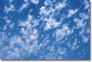
Weather Topic: What are Fractus Clouds?
Home - Education - Cloud Types - Fractus Clouds
 Next Topic: Freezing Rain
A fractus cloud (scud) is a fragmented, tattered cloud which has
likely been sheared off of another cloud. They are accessory clouds, meaning they
develop from parent clouds, and are named in a way which describes the original
cloud which contained them.
Fractus clouds which have originated from cumulus clouds are referred to as
cumulus fractus, while fractus clouds which have originated from stratus clouds
are referred to as stratus fractus. Under certain conditions a fractus cloud might
merge with another cloud, or develop into a cumulus cloud, but usually a
fractus cloud seen by itself will dissipate rapidly.
They are often observed on the leading and trailing edges of storm clouds,
and are a display of wind activity.
Next Topic: Freezing Rain
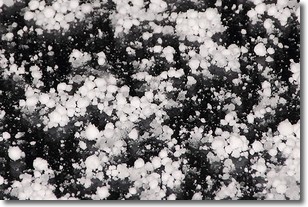
Weather Topic: What is Graupel?
Home - Education - Precipitation - Graupel
 Next Topic: Hail
Graupel is a form of precipitation that is created by atmospheric conditions
which cause supercooled water droplets to contact snow crystals and freeze to
their surface.
Sometimes known as soft hail or snow pellets, graupel is delicate and easily
destroyed by touch. Whereas hail usually falls during severe weather, graupel
doesn't require such conditions to form, and can form in mild precipitation
similar to situations which produce snowfall.
Next Topic: Hail
Current conditions powered by WeatherAPI.com


