Weather Alert in Alaska
Winter Storm Warning issued February 21 at 11:21AM AKST until February 23 at 9:00PM AKST by NWS Fairbanks AK
AREAS AFFECTED: Yukon Delta Coast; Lower Yukon River; Lower Yukon and Innoko Valleys
DESCRIPTION: * WHAT...Heavy mixed precipitation expected. Total snow accumulations up to 5 inches and ice accumulations up to 0.10 inches. * WHERE...Lower Yukon River, Lower Yukon and Innoko Valleys, and Yukon Delta Coast. * WHEN...From 3 AM Sunday to 9 PM AKST Monday. * IMPACTS...Travel may be impacted. * ADDITIONAL DETAILS...A lighter snow with a chance for some light wintry mix is expected Saturday. Heavier precipitation begins Sunday morning starting mostly as rain or a wintry mix and eventually switching back to mostly snow Monday afternoon. Much of the precipitation will be rain that is expected to freeze on the ground, but not along power lines and other elevated surfaces. Temperatures cool rapidly Tuesday and Wednesday causing pooling water to freeze.
INSTRUCTION: If you must travel, keep an extra flashlight, food, and water in your vehicle in case of an emergency.
Want more detail? Get the Complete 7 Day and Night Detailed Forecast!
Current U.S. National Radar--Current
The Current National Weather Radar is shown below with a UTC Time (subtract 5 hours from UTC to get Eastern Time).

National Weather Forecast--Current
The Current National Weather Forecast and National Weather Map are shown below.

National Weather Forecast for Tomorrow
Tomorrow National Weather Forecast and Tomorrow National Weather Map are show below.

North America Water Vapor (Moisture)
This map shows recent moisture content over North America. Bright and colored areas show high moisture (ie, clouds); brown indicates very little moisture present; black indicates no moisture.

Weather Topic: What are Altostratus Clouds?
Home - Education - Cloud Types - Altostratus Clouds
 Next Topic: Cirrocumulus Clouds
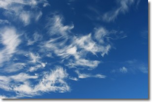
Altostratus clouds form at mid to high-level altitudes
(between 2 and 7 km) and are created by a warm, stable air mass which causes
water vapor
to condense as it rise through the atmosphere. Usually altostratus clouds are
featureless sheets characterized by a uniform color.
In some cases, wind punching through the cloud formation may give it a waved
appearance, called altostratus undulatus. Altostratus clouds
are commonly seen with other cloud formations accompanying them.
Next Topic: Cirrocumulus Clouds
Weather Topic: What are Cirrostratus Clouds?
Home - Education - Cloud Types - Cirrostratus Clouds
 Next Topic: Cirrus Clouds
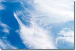
Cirrostratus clouds are high, thin clouds that form above
20,000 feet and are made mostly of ice crystals. They sometimes look like giant
feathers, horse tails, or curls of hair in the sky.
These clouds are pushed by the jet stream and can move at high speeds reaching
100 mph.
What do they indicate?
They indicate that a precipitation is likely within 24 hours.
Next Topic: Cirrus Clouds
Current conditions powered by WeatherAPI.com


