Weather Alert in Indiana
Flood Warning issued March 4 at 12:50PM EST until March 5 at 2:21AM EST by NWS Indianapolis IN
AREAS AFFECTED: Owen, IN
DESCRIPTION: ...The Flood Warning continues for the following rivers in Indiana... Buck Creek at Acton. Sugar Creek near Edinburgh. Clifty Creek at Hartsville. ...The Flood Warning is extended for the following rivers in Indiana... Mill Creek near Cataract. .Rainfall amounts between two and four inches over parts of central and southern Indiana have led to rises and some flooding on area rivers. Additional rainfall of one to three inches this evening into Thursday morning, with locally higher amounts possible, will bring widespread minor river flooding with pockets of moderate flooding to much of the East Fork White and lower White River basins. * WHAT...Minor flooding is occurring and minor flooding is forecast. * WHERE...Mill Creek near Cataract. * WHEN...Until just after midnight tonight. * IMPACTS...At 15.0 feet, Mill Creek at flood stage. Camp Otto Road begins to flood. Low pasture land along Mill Creek begins to flood. * ADDITIONAL DETAILS... - At 12:15 PM EST Wednesday the stage was 15.5 feet. - Recent Activity...The maximum river stage in the 24 hours ending at 12:15 PM EST Wednesday was 15.6 feet. - Forecast...The river is expected to fall below flood stage this evening and continue falling and remain below flood stage. - Flood stage is 15.0 feet. - http://www.weather.gov/safety/flood
INSTRUCTION: Motorists should not attempt to drive around barricades or drive cars through flooded areas. Additional information is available at www.weather.gov/ind. The next statement should be issued this evening by around 1100 PM EST.
Want more detail? Get the Complete 7 Day and Night Detailed Forecast!
Current U.S. National Radar--Current
The Current National Weather Radar is shown below with a UTC Time (subtract 5 hours from UTC to get Eastern Time).

National Weather Forecast--Current
The Current National Weather Forecast and National Weather Map are shown below.

National Weather Forecast for Tomorrow
Tomorrow National Weather Forecast and Tomorrow National Weather Map are show below.

North America Water Vapor (Moisture)
This map shows recent moisture content over North America. Bright and colored areas show high moisture (ie, clouds); brown indicates very little moisture present; black indicates no moisture.

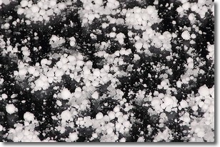
Weather Topic: What is Graupel?
Home - Education - Precipitation - Graupel
 Next Topic: Hail
Graupel is a form of precipitation that is created by atmospheric conditions
which cause supercooled water droplets to contact snow crystals and freeze to
their surface.
Sometimes known as soft hail or snow pellets, graupel is delicate and easily
destroyed by touch. Whereas hail usually falls during severe weather, graupel
doesn't require such conditions to form, and can form in mild precipitation
similar to situations which produce snowfall.
Next Topic: Hail
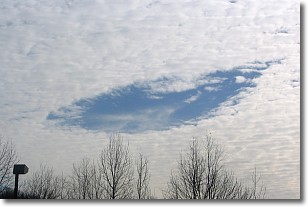
Weather Topic: What are Hole Punch Clouds?
Home - Education - Cloud Types - Hole Punch Clouds
 Next Topic: Mammatus Clouds
A hole punch cloud is an unusual occurrence when a disk-shaped
hole appears in a cirrostratus, cirrocumulus, or altocumulus cloud.
When part of the cloud forms ice crystals, water droplets in the surrounding area
of the cloud evaporate. The effect of this process produces a large elliptical
gap in the cloud. The hole punch cloud formation is rare, but it is not specific
to any geographic area.
Other names which have been used to describe this phenomena include fallstreak hole,
skypunch, and cloud hole.
Next Topic: Mammatus Clouds
Current conditions powered by WeatherAPI.com


