Weather Alert in Indiana
Flood Warning issued March 4 at 12:50PM EST until March 5 at 7:23AM EST by NWS Indianapolis IN
AREAS AFFECTED: Marion, IN
DESCRIPTION: ...The Flood Warning continues for the following rivers in Indiana... Buck Creek at Acton. Sugar Creek near Edinburgh. Clifty Creek at Hartsville. ...The Flood Warning is extended for the following rivers in Indiana... Mill Creek near Cataract. .Rainfall amounts between two and four inches over parts of central and southern Indiana have led to rises and some flooding on area rivers. Additional rainfall of one to three inches this evening into Thursday morning, with locally higher amounts possible, will bring widespread minor river flooding with pockets of moderate flooding to much of the East Fork White and lower White River basins. * WHAT...Minor flooding is occurring and minor flooding is forecast. * WHERE...Buck Creek at Acton. * WHEN...Until tomorrow morning. * IMPACTS...At 12.0 feet, Extensive lowland flooding along Buck Creek in southeast Marion and northwest Shelby Counties. Flooding affects agricultural and recreational areas. Flooding may affect some residential areas. Shelby CR 700N one quarter of a mile east of Shelby CR 875 is flooded by more than one foot of water especially if Sugar Creek at New Palestine is 8 feet or higher. * ADDITIONAL DETAILS... - At 12:00 PM EST Wednesday the stage was 10.6 feet. - Recent Activity...The maximum river stage in the 24 hours ending at 12:00 PM EST Wednesday was 10.6 feet. - Forecast...The river is expected to rise to a crest of 10.8 feet this afternoon. It will then fall below flood stage just after midnight tonight. - Flood stage is 9.0 feet. - http://www.weather.gov/safety/flood
INSTRUCTION: Motorists should not attempt to drive around barricades or drive cars through flooded areas. Additional information is available at www.weather.gov/ind. The next statement should be issued this evening by around 1100 PM EST.
Want more detail? Get the Complete 7 Day and Night Detailed Forecast!
Current U.S. National Radar--Current
The Current National Weather Radar is shown below with a UTC Time (subtract 5 hours from UTC to get Eastern Time).

National Weather Forecast--Current
The Current National Weather Forecast and National Weather Map are shown below.

National Weather Forecast for Tomorrow
Tomorrow National Weather Forecast and Tomorrow National Weather Map are show below.

North America Water Vapor (Moisture)
This map shows recent moisture content over North America. Bright and colored areas show high moisture (ie, clouds); brown indicates very little moisture present; black indicates no moisture.

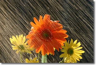
Weather Topic: What is Precipitation?
Home - Education - Precipitation - Precipitation
 Next Topic: Rain
Precipitation can refer to many different forms of water that
may fall from clouds. Precipitation occurs after a cloud has become saturated to
the point where its water particles are more dense than the air below the cloud.
In most cases, precipitation will reach the ground, but it is not uncommon for
precipitation to evaporate before it reaches the earth's surface.
When precipitation evaporates before it contacts the ground it is called Virga.
Graupel, hail, sleet, rain, drizzle, and snow are forms of precipitation, but fog
and mist are not considered precipitation because the water vapor which
constitutes them isn't dense enough to fall to the ground.
Next Topic: Rain
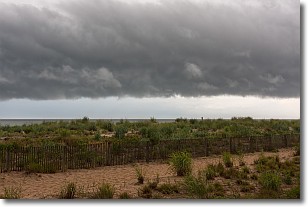
Weather Topic: What are Shelf Clouds?
Home - Education - Cloud Types - Shelf Clouds
 Next Topic: Sleet
A shelf cloud is similar to a wall cloud, but forms at the front
of a storm cloud, instead of at the rear, where wall clouds form.
A shelf cloud is caused by a series of events set into motion by the advancing
storm; first, cool air settles along the ground where precipitation has just fallen.
As the cool air is brought in, the warmer air is displaced, and rises above it,
because it is less dense. When the warmer air reaches the bottom of the storm cloud,
it begins to cool again, and the resulting condensation is a visible shelf cloud.
Next Topic: Sleet
Current conditions powered by WeatherAPI.com


